Author Archives: nzartig

Papamoa Hills – Te Rae o Papamoa Track

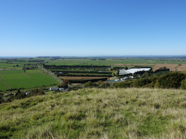
Although most of Te Rae o Papamoa Track in the Papamoa Hills Cultural Heritage Regional Park has been covered in a previous post an interesting extension to the track is now shown on some of the information panels within the park. It provides an alternative to the Karangaumu Summit Track for a walk to the summit, and since it can easily connect to the Valley and Puriri Tracks and on to Maraeroa Track it can provide a longer and more varied walk within the park area.

This walk, which starts at the carpark on Poplar Lane off Te Puke Highway, takes the Karangaumu Summit Track up to the start of Te Rae o Papamoa Track, then follows this track and a service road up to the summit. On the way back it branches off at the Papamoa Pa site and follows the longer route back to the service road and the track back to the carpark. A total distance of about 7 km for a total time of 2 hours including time to visit the pa sites along the way.

Continue reading

Papamoa Hills – Maraeroa, Valley and Puriri Tracks

There are a number of walking tracks in the Papamoa Hills Cultural Heritage Regional Park near Tauranga, but several of these are currently unmarked and only shown on aerial photos at various locations within the park. One of the longest and most varied of these tracks, the Maraeroa Track, is only shown on the information panel by the carpark on Poplar Lane, off Te Puke Highway (the old SH2). The most used track is the Karangaumu Summit Track, and the lower part of this track also provides access to the other tracks within the park.

The tracks described here are the Maraeroa , Valley and Puriri tracks. Maraeroa Track branches off the summit track and returns to the summit track about 150 metres further up. Valley Track and Puriri Track branch off Maraeroa Track and can also connect with Te Rae O Papamoa Track. For an older description of the summit track and part of Te Rae O Papamoa Track see the previous post Papamoa Hills Cultural Heritage Regional Park.

Continue reading

Te Ara O Wairakei, Papamoa East

Te Ara O Wairakei in Papamoa, also known as the Papamoa Drainage Reserve or Papamoa Stormwater Reserve, is a collection of reserves in Papamoa running parallel with the oceanfront, with cycleways/walkways running through them. Currently Te Ara O Wairakei is divided into two completely separate parts. The longer part runs for about 6 km from near Parton Road to Pacific View Road. The shorter part in Papamoa East runs for about 1.5 km from near Mandalay Key to Gibson Place.

The part from Parton Road to Pacific View Road has been described in two previous posts – Papamoa Beach, Wairakei, Topaz Drive Reserves and Papamoa Drainage Reserve – Domain Rd to Pacific View Rd before the name change to Te Ara O Wairakei. This post describes the separate part of Te Ara O Wairakei in Papamoa East.

Continue reading

Lake Kainui, Horsham Downs

Lake Kainui is a peat lake of about 25 hectares in the Horsham Downs area of Waikato, east of Ngaruawahia and north of Hamilton. It is one of a series of lakes in the area, and is also known as Lake D or Lake Rotoaira. Lakes A, B and C are nearby. A walkway around the lake was opened in 2018, and public access to the lake itself and Lake Kainui Reserve was arranged by the Waikato District Council. A short access road off Lake Road leads to a parking area and the reserve. There is also a boat ramp and a toilet.

Various activities are permitted in the reserve and on the lake, but some activities require a permit and access to the boat ramp requires a key. The reserve may be closed to the public in May, during the duck shooting season. The walkway around the perimeter of the lake is about 3.1 km long, mostly well formed with a gravel surface, although there are also areas of grass. There are no steps and only the gentlest of gradients, with an elevation difference of only a metre or two along the entire track.

Continue reading

White Pine Bush, Awakeri – Taneatua

White Pine Bush, adjacent to SH2 between Awakeri and Taneatua, is a 4.5 hectare reserve containing one of the last stands of lowland kahikatea forest in the area. The trees in the forest area are mainly kahikatea, tawa, pukatea, and nikau. A bridge across Waioho Stream and a 250-metre long, level track suitable also for wheelchairs, has been formed as a loop through the forest. Information panels show details of the forest, the birds, and the predators.

A parking area is accessible directly from SH2, between Awakeri and Taneatua, and about 20km south of Whakatane. There are no toilets or other facilities at the site. A gumboot fence forms part of the boundary to the carpark. The walk can easily be done in 10 minutes, including time for reading the information panels. It would be suitable as a short break for travellers driving through SH2. Continue reading

Karangahake Windows Walk

The Windows Walk in the Karangahake Gorge is a short walk through an area with relics from a gold mining period in the late 19th and early 20th centuries. The walk can be done as a loop, with the windows section in one direction and the Crown Tramway Track in the other direction, both of them running parallel to the Waitawheta River, near the junction with Ohinemuri River. Numerous information panels describe some of the history of the area, with photos of the extensive buildings which once were located here.

The walk is easily accessible from a parking area off State Highway 2 at the western end of Karangahake Gorge. Toilets are located by the parking area. Information about the walk can be found on the Department of Conservation web site. A torch is very strongly recommended for walking through the mine tunnel with the windows looking into the Waitawheta Gorge. The Crown Tramway Track may be closed during heavy rain or when there have been rockfalls, and the underground pumphouse mentioned on the DoC web site has been closed off for several years now. Continue reading

Pipiwharauroa Trail, Raglan

Pipiwharauroa Trail is a walking and cycling trail near Raglan, starting from Kawhia Road near Waireinga/Bridal Veil Falls, and ending at the Te Uku Wind Farm. For a large part of the trail it uses a wide gravel road used for access to the wind farm, and for the remainder it uses old farm tracks. The last 1.5 km or so is the roughest part of the trail. The trail passes through actively farmed private land, so dogs are definitely not allowed.

Te Uku Wind Farm is a 28-turbine wind farm, situated on private farmland on the Wharauroa Plateau. It can generate 64.4 MW of power. Construction commenced in 2009 and the wind farm was operational in 2010. It was officially opened in February 2011. Information about the wind farm, including photos from the construction phase, can be found on the Meridian Energy web site. There is a lookout in Te Uku, on SH23 between Hamilton and Raglan, where part of the wind farm can be viewed from a distance. Continue reading

Waireinga/Bridal Veil Falls, Raglan

Waireinga/Bridal Veil Falls is a 55-metre high, spectacular waterfall in the Raglan area of Waikato. The falls are well signposted and accessible from SH23, along Te Mata Road and continuing about 4 km along Kawhia Road. There is a parking area alongside Kawhia Road, and a wide track with an easy gradient leads from the parking area, past DoC toilets and a picnic area, to the top of the falls. At the top of the falls there are two viewing platforms, one looking straight down the waterfall and the other looking across to the whole waterfall.

The easy track to the top of the waterfalls is about 500 metres long, and follows the Pakoka River through native forest. The track from the top to the bottom of the falls is steep, with 261 formed steps. About halfway down there is another viewing platform, and at the bottom there is a bridge across Pakoka River with direct views of the falls, and a shelter with information panels. Information about the falls can be found on the DoC web site. Dogs are not allowed at the falls, and the water is not suitable for swimming.

Continue reading

Puketoromiro Pa site, Tauranga

The Puketoromiro Pa site in the Kopurererua Valley has been cleared of the eucalyptus trees growing on it, and a set of steps crossing over the summit have been constructed, with a connecting walkway/cycleway from the existing path through the valley. Currently the site has not officially been opened, and there are currently no information panels by the site. But the gates have been opened and people are accessing the site.

The only information about the new walk across the pa site is apparently an article on the SunLive web site, which has some historical information and expects the completion with interpretation panels and replanted native vegetation in August 2020. This post will be updated after the track has been officially opened and information panels erected.

Continue reading

MacMillan Reserve and Tamawhariua Reserve, Katikati

A parking area at the eastern end of Beach Road, Katikati, provides access to MacMillan Reserve to the north, and Tamawhariua Reserve and Coastal Walkway to the south. MacMillan Reserve provides walking and cycling access along the foreshore and then to the eastern end of Pukakura Road. Tamawhariua Reserve runs alongside the foreshore before heading back to Beach Road, ending on Beach Road about 500 metres from the carpark. There are toilets in the carpark, and a boat ramp off the end of Beach Rd.

There appears to be very little information about the reserves, and although the Tamawhariua Reserve is mentioned very briefly in a Western Bay of Plenty District Council page about cycle and walking trails there were no signs on the route indicating it’s name. It is signposted as a public walkway and cycle way and is also open to mobility scooters. Dogs are permitted, but must be kept under control at all times. It appeared to be a popular route for dog walkers. Horses and motorcycles are not allowed.

Continue reading