Tag Archives: Karangahake

Karangahake Windows Walk

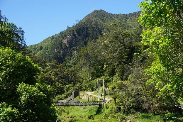
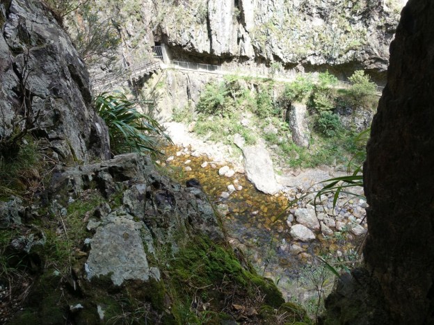
The Windows Walk in the Karangahake Gorge is a short walk through an area with relics from a gold mining period in the late 19th and early 20th centuries. The walk can be done as a loop, with the windows section in one direction and the Crown Tramway Track in the other direction, both of them running parallel to the Waitawheta River, near the junction with Ohinemuri River. Numerous information panels describe some of the history of the area, with photos of the extensive buildings which once were located here.

The walk is easily accessible from a parking area off State Highway 2 at the western end of Karangahake Gorge. Toilets are located by the parking area. Information about the walk can be found on the Department of Conservation web site. A torch is very strongly recommended for walking through the mine tunnel with the windows looking into the Waitawheta Gorge. The Crown Tramway Track may be closed during heavy rain or when there have been rockfalls, and the underground pumphouse mentioned on the DoC web site has been closed off for several years now. Continue reading

Golden Cross Mine to Maratoto Road

Gold was discovered at Golden Cross in 1892, and an underground mine operated there from 1895 to 1920, extracting over 2.5 tonnes of gold from about 160,000 tonnes of ore. The area reverted to farmland after the mine was closed, until the new Golden Cross Mine started operating in late 1991. The new mine operated as both an open-cast and an underground mine. The mine closed again in late 1997 – early 1998 after extracting 18 tonnes of gold and 52 tonnes of silver. Water from the mine site is still being treated, and the tailings dam is still present.

The mine site is about 12 km from SH2, and accessible at the northern end of Golden Cross Road, an extension of Waitekauri Road, off SH2 between Karangahake and Waihi. Old Waitekauri Rd and Campbell Rd also connect SH2 to Waitekauri Rd. There is a large parking area at the mine site, but no other facilities. The access gate near the end of Golden Cross Rd is opened at dawn and closed at dusk each day.

Continue reading

Dickey Flat – Mangakino Pack Track Loop

Dickey Flat Campsite in the Karangahake Gorge is the starting point of various walks in the Kaimai Mamaku Forest Park. The Mangakino Pack Track Loop is one of the longer and most difficult of the loop walks starting and ending at the campsite. The tracks making up this loop have various names depending on the source, which can be confusing. For example the Mangakino Pack Track is also known as Mangakino Track and Mangakino Stream Track. Dickey Flat is also called Dickey’s Flat on older DoC signs.

The campsite, with parking area and basic toilet facilities, is located at the end of Dickey Flat Road, off Kennedy Rd and Waitawheta Rd. The last part of Dickey Flat Rd is a narrow, gravel road.

Continue reading

County Rd to Mt Karangahake Summit

There are several tracks leading to the summit of Mt Karangahake, a prominent peak visible from SH2 between Paeroa and Waihi. The post Mt Karangahake summit describes the most often used tracks, the Mountain Track and the unmarked and unnamed direct track which branches off the Mountain Track.

This walk was done on the County Rd track, part of which is also known as the Number 7 Level Track, with the Mountain Link Track joining County Rd to the Mountain Track and the summit. This route is somewhat longer than the other two tracks, but most of County Rd has an easy gradient and is a good, well-formed track. The Mountain Link Track is narrower and steeper, but not very long. The return from the summit was via the unmarked direct track and the Mountain Track.

Continue reading

Dickey Flat to Karangahake loop

The Dickey Flat campsite, administered by DoC, is located on the banks of the Waitawheta River in the Karangahake Gorge and the Kaimai Mamaku Forest Park. Located at the end of Dickey Flat Rd, off Kennedy Rd and Waitawheta Rd, it is a popular campsite in the summer, with swimming holes and trout fishing spots easily accessible.

Two walking tracks, which can be walked as a loop walk, connect Dickey Flat and Karangahake. The south-western track passes through regenerating native bush, with the north-eastern track following the Waitawheta River and the historic Waitawheta pipeline. The total loop has a length of just over 10km. It can be walked in either clockwise or anti-clockwise direction, and starting at either Dickey Flat campsite, or by SH2 at Karangahake.

Continue reading

Dean, Mangakino Pack, Daly’s Clearing and Waitawheta Tramway Tracks

A loop walk in the Kaimai Forest Park, starting and ending on Franklin Rd near Karangahake, uses the Dean Track, part of the Mangakino Pack Track, Daly’s Clearing Track, and part of the Waitawheta Tramway Track. At the Franklin Rd end the walk passes through privately-owned farmland. There is a small parking area on Franklin Rd, but no toilet or other facilities.

The walk consists mainly of tracks with an easy contour, although there is an elevation difference of about 240m between the lowest and highest points. More information about the loop walk can be found on the DoC web site, although the information there does not quite agree with the GPS data. The GPS shows a total distance of about 9.2 km, instead of 7.5km.

Continue reading

Bluff Stream Kauri Loop

Two of the largest Kauri trees in the Kaimai-Mamaku Forest Park can be seen alongside the Bluff Stream Kauri Loop Track. The track is accessible from the end of Franklin Rd, off Waitawheta Rd, between Waihi and Karangahake. The loop track passes around Maungawhio, a 366m high dome-shaped knoll. The large Kauri trees are on the south-eastern side of Maungawhio.

The most difficult part of the walk are the river crossings, especially during winter or after heavy rainfall. The track crosses the Waitawheta River twice, and Bluff Stream, a tributary to Waitawheta River, once. Both were about knee deep at all 3 crossing locations during this walk.

Continue reading

Karangahake Tunnel Loop to Owharoa Falls

There are several walking and mountain biking tracks in the Karangahake Gorge between Waihi and Paeroa. The Karangahake Gorge Historic Walkway mostly follows the route of the old railway running through the gorge. The railway was closed and the rails removed in the 1970s, but some of the rail bridges still exist, and the rail line between Waikino and Waihi has been reopened for passengers on the Goldfields Railway.

The walkway/cycleway is now open from Waihi to Karangahake Hall as the western end of the gorge. Parking is available by the Karangahake Reserve, accessible directly from SH2, and further west by the Western Portal Bridge, which crosses SH2. The lower level of the bridge is a one-lane road bridge.

Continue reading

Mt Karangahake summit

Mt Karangahake towers above the western end of Karangahake Gorge, between Waihi and Paeroa. It is clearly visible from SH2, the main road through the gorge. The most prominent peak has a trig station on top, with an official elevation of 544m above sea level. The highest point is a few metres higher, but not easily accessible. However, a nearby peak with a communication mast on top is accessible, and is slightly higher than the trig station.

There are 3 tracks leading to the summit, all of which are accessible from the main carpark on SH2, or from the nearby carpark on County Rd, or from Crown Hill Rd where there is a small parking area near a locked gate. There are toilet facilities both at the main carpark, and by the County Rd carpark. County Rd is accessible from SH2 across a one-lane, two-level bridge, originally used for both rail and road, with the railway above the roadway.

Continue reading