Tag Archives: Te Puke

Otawa trig from Manoeka Road

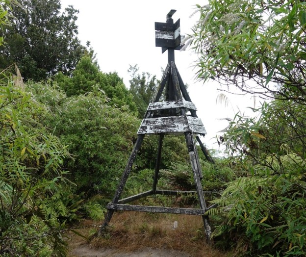
Otawa Scenic Reserve is an area of native forest south-east of Tauranga and south-west of Te Puke. Otawa trig, at an elevation of 565 metres, is the highest point within the reserve. The trig is accessible from several locations, including a track which starts at the end of Manoeka Road, climbing to meet up with the track from Demeter Road and Otanewainuku, with a short steeper section before reaching the trig station. There are no views from the trig station, or from the track which has vegetation cover for the entire length.

The Otawa Scenic Reserve is managed by DoC, and a short description of the reserve and some of the tracks is found on their web site. An alternative and easier route to the trig station is described in the post Otawa Trig from Te Puke Quarry Road on this site.

Continue reading

Te Ara Kahikatea Pathway, Te Puke

Note December 9, 2020: The track has reopened, probably some time ago, after a new rail bridge was constructed.

Te Ara Kahikatea Pathway is a 4 km long walkway and cycleway passing through wetlands and alongside Waiari Stream on the eastern outskirts of Te Puke. The pathway starts and ends at the Hera Memorial adjacent to a parking area off Commerce Lane. The pathway crosses over Jubilee Park and runs along Stock Rd and King St before forming a loop around a rural part of Te Puke.

The pathway was established by volunteers organised by Te Ara Kahikatea Pathway Incorporated Society starting in 2011, and was officially opened in April 2018 by the mayor of Western Bay of Plenty District Council. A mix of native plants, including kahikatea, have been planted alongside the pathway.

Continue reading

Raparapahoe Falls

Raparapahoe Falls is a 3-metre high waterfall on the Raparapahoe Stream, plunging into a large pool at the bottom of a valley with very steep sides. The stream and waterfall is accessible by a short but steep and rough track starting at a small parking area on No 4 Road near Te Puke. A narrow bridge on No 4 Road crosses over Raparapahoe Stream not far from No 3 Road, with the road continuing through mainly kiwifruit orchards to the parking area and track start. It continues on to another narrow bridge, crossing over Wairapukao Stream, a tributary to Raparapahoe Stream.

Continue reading

Otawa Trig from Te Puke Quarry Road

The Otawa Scenic Reserve in the Papamoa Hills is part of the Kaimai Mamaku Forest Park. The scenic reserve is accessible from various location near Tauranga and Te Puke, including Te Puke Quarry Road, Manoeka Rd, and Demeter Rd. The Trig Track runs from Te Puke Quarry Rd, via the Otawa trig, to Manoeka Rd by Otawa Lodge.

This walk covers the track from Te Puke Quarry Rd, past the Otawa trig, to the junction where the track to Manoeka Rd joins the track to Demeter Rd and to Whataroa Falls and Otanewainuku.

Continue reading

Papamoa Hills Cultural Heritage Regional Park

Note: The park reopened on June 3, 2017 after being closed since October, 2016 for pine tree harvesting.

New photos taken after the re-opening at the end of the post.
————————————–

The Papamoa Hills Cultural Heritage Regional Park near Tauranga was opened in 2004 as the first regional park outside the Auckland and Wellington regions. It contains a number of early Maori pa sites within a small area, with ditches, middens, and terracing on the hillsides.

The main walkway starts by a carpark at the end of Poplar Lane, off SH2 between Tauranga and Te Puke, and ascends through radiata pine forest to open farmland, and the pa at highest point in the park. There are walkways to other pa sites, and to the Summerhill mountain biking tracks.

Continue reading