Note December 9, 2020: The track has reopened, probably some time ago, after a new rail bridge was constructed.
Te Ara Kahikatea Pathway is a 4 km long walkway and cycleway passing through wetlands and alongside Waiari Stream on the eastern outskirts of Te Puke. The pathway starts and ends at the Hera Memorial adjacent to a parking area off Commerce Lane. The pathway crosses over Jubilee Park and runs along Stock Rd and King St before forming a loop around a rural part of Te Puke.
The pathway was established by volunteers organised by Te Ara Kahikatea Pathway Incorporated Society starting in 2011, and was officially opened in April 2018 by the mayor of Western Bay of Plenty District Council. A mix of native plants, including kahikatea, have been planted alongside the pathway.
The parking area on Commerce Lane also has toilet facilities, and there are parking spaces available for freedom campers. Dogs are permitted on the pathway if they are kept on a leash. The pathway loop can be walked in a clockwise or anticlockwise direction. The photos show a clockwise walking direction.
An information panel with a diagram and marked places of interest can be found in 3 places: by the Hera Memorial where the pathway starts and ends, at the junction by Tinkerbell’s Garden where the loop starts and ends, and at the entrance to the old cemetery on Landscape Road.

The parking area on Commerce Lane on the right, and the Hera Memorial arch just to the left of centre.

The Hera Memorial and the Te Ara Kahikatea Pathway information panel. The first part of the pathway is not a formed track. It crosses over the grass area on the right, to the buildings that can be seen on the far right.

The exit from Jubilee Park by the toy library. The small sign on the right indicates Te Ara Kahikatea Pathway, and is found in numerous locations along the track. Here the pathway continues along Stock Road to the right, towards King Street.

A large, old oak tree is located at the end of King Street, near where the pathway descends to the loop section.

Next to the oak tree there is an entrance to and a view over Tinkerbell’s Garden.

The path descends from the end of King Street down to the low-lying area where the loop path is located.

From here the junction with the start and end of the loop track is visible. The clockwise track branches off to the left at the centre of the photo, with the anticlockwise direction off to the right. An information panel is located at the junction.

The only larger kahikatea seen along the pathway was this mid-sized one trying to grow up between various other trees.

The pathway passes under the railway line twice. Here the pathway continues as a boardwalk across low-lying fields.

After the first boardwalk the pathway follows alongside an extension to Gordon Street, leading to the animal pound and the wastewater treatment plant which can be seen to the right.

The pathway crosses over the road, through two gates which should be closed, and then continues as a boardwalk past the animal pound.

The pathway then runs along the top of the stopbank adjacent to Waiari Stream, which can be seen on the left, following the stream to Te Puke Highway.

The second railway underpass is much lower and more restricted than the first. Cyclists should dismount when passing through. There are signs that recent heavy rains have had the stream running as high as the protective netting.

After the underpass the pathway follows alongside the stream and stopbank, instead of being on top of the stopbank. This part of the pathway could be flooded after heavy and persistent rain. There are distance markers every kilometre. Here the 2km marker.

Apparently there is a swimming hole in the Waiari Stream under the bridge on Te Puke Highway, with a rope swing attached to the bridge.

The pathway climbs to the top of the stopbank and then descends on the other side. This is looking back down the stream from the bridge on Te Puke Highway, with the pathway continuing on the left.

The driveway on the left joins onto Te Puke Highway. Te Ara Kahikatea continues along to the right of the power pole towards the old cemetery which can be seen in front of the trees in the distance on the right.

Looking back towards Te Puke Highway from the gentle climb up to the old cemetery.

The pathway continues straight through the old cemetery to Landscape Road.

Another information panel can be found on Landscape Road, by the entrance to the cemetery. The pathway continues a short distance along Landscape Road, branching off to the left.

A tarsealed road leads off Landscape Road down to a parking area and picnic tables by Lawrence Oliver Park.

The little white bridge crosses over a drain.


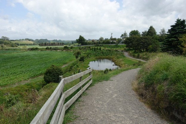
The track heading up the hill on the left continues on to Jellicoe Street. Te Ara Kahikatea is the gravel track heading off to the right, towards the trees on the far right.

The pathway follows the lower level of Tinkerbell’s Garden, back to the junction where the loop starts and ends, and then back up the hill past the old oak tree which can be seen on the skyline at photo centre. From here follow the same path back to Jubilee Park and the end of the track at the Hera Memorial.

The GPS tracklog shows the route taken, starting and ending at Jubilee Park on the left. Total walking distance was 4.0 km, and the time was one hour, including plenty of time for photos.

The aerial photo, from Google Maps, shows the same area, with some of the places of interest marked. The boardwalks have been built after this photo was taken.

The track was walked on January 5, 2019 and December 9, 2020.

Good rural walk , an asset for Te Puke
LikeLike
Yes, it is. I try to walk around it whenever I’m in Te Puke with a bit of time to spare.
LikeLike
Was closed about 3km along so we were forced to turn back.
LikeLike
Thanks. There’s a small notice in today’s Bay of Plenty Times about the closure near King Street as KiwiRail replaces the rail bridge. Apparently the closure will last until February 2020.
LikeLike