Tarawera Falls is an impressive group of waterfalls in Lake Tarawera Scenic Reserve, with the river emerging from various locations on a sheer rock face. After heavy rain there may also be water cascading down from the top of the rock face. A walking track about 5 km long links the Tarawera Outlet where water from the eastern end of Lake Tarawera at Tapahoro Bay forms the beginnings of the Tarawera River, to the Tarawera Falls lookout, and further on to a carpark on Waterfall Road. The only road access to the outlet and to the falls is from Kawerau, along gravel forest roads which require a permit to enter.
There is a DoC campground by the outlet, at the end of Tarawera Road, with parking and toilet facilities. There is also a parking area at the end of Waterfall Road, near the base of the Tarawera Falls, with a basic DoC toilet. Information about the waterfall, campgrounds, and walking tracks can be found on the DoC web site. This also includes information about obtaining a permit to access the locations by road from Kawerau.
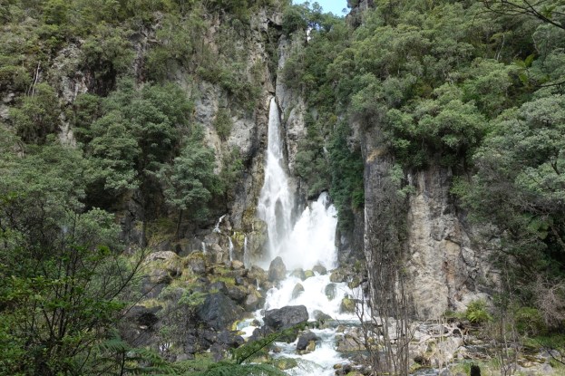
The original name for Tarawera Falls, said to be the most spectacular falls in the Bay of Plenty, is Te Tatau a Hape, or ‘the doorway of Hape’. Hape, an early explorer from Hawaiki searching for pounamu or greenstone, is said to have placed the boulder above the falls which forces the river underground. The falls are about 65 metres high.
The track from the Waterfall Road carpark to the Tarawera Falls lookout has an easy contour, with no steps or steep gradients. A bridge crosses the Tarawera River. The track from the waterfall lookout to the Tarawera Outlet is steeper, narrower, and has a few steps along the way. There are two options. The longer and more interesting option is the Cascades Loop which follows the river and passes by some cascades and locations where parts of Tarawera River disappear underground. The other option is more direct and about 600 metres shorter, bypassing the cascades viewing areas. The last part of the track approaching the outlet are mostly an easier gradient. A short length of the track has no shade, but most of it has good vegetation coverage with shade.
The walk was done starting from the carpark at the end of Waterfall Road, past the waterfall lookout, along the Cascades Loop and on to the Tarawera Outlet and campground. The return walk was on the shorter bypass route. The Tarawera Ultramarathon was held on the same day, so there were various markers along the track. The 102 km race entrants had all passed through, and only a few of the 160 km entrants were on their way to the outlet at the time. Total walking distance was 10.3 km for a total time of 2 hours 40 minutes.
The car parking area at the end of Waterfall Road. Apparently there is a DoC toilet nearby. The entry to the waterfall track is at the far end of the carpark.

The information panel at the entrance to the walkway clearly shows the Cascades Loop track and information about track lengths and walking times.

The track from the carpark to the falls lookout is well formed and follows closely alongside the Tarawera River.

A pedestrian bridge crosses over the river about halfway between the carpark and the falls lookout.

There are some huge boulders alongside the track.

An information panel near the falls lookout in the Tarawera Scenic Reserve.

There is a bench at the waterfall lookout, with great views of the Tarawera Falls.


Continuing on from the falls the track is narrower and steeper, with some steps, as it climbs up towards the top of the falls.

Near the top the track continues straight ahead along the Cascades Loop, or branches off to the right for the more direct track to the outlet. The tape across the track is for the runners who have to take the longer loop track.

There are numerous cascades visible along the loop track. Here is one of the locations where parts of the river disappear underground, at bottom right of the photo.

Looking back at the upper junction of the loop track and the direct track. The difference in distance shown here is 400 metres, with an extra 5 minutes required for the loop track.

Continuing on towards the outlet there are other cascades and waterfalls. Here a warning against swimming in the pool as part of the river goes underground at this location.

The waterfall above the pool where part of the river goes underground.

Continuing along the track towards the outlet there are more cascades.

A steep section of the track bypasses an earlier rockfall. There are well formed steps on one side of the bypass.

On the other side the steps are not quite as well formed, and there is a rope tied up as a handrail for these and a slippery scoria section below.

The track is very close to the river in places, so some care is required when the track is wet and slippery,

Approaching the outlet there is a short part of the track with no shade. The remainder of the track has tree or vegetation coverage with good shade.

By the outlet and the bridge across the Tarawera River there is another tramping track leading to Humphries Bay and on to Okataina Road.

Looking from the bridge, along the start of the Tarawera River to Tapahoro Bay on Lake Tarawera.

The summit of Mount Tarawera is clearly visible from the bridge by the Tarawera Outlet. The campground is located behind the trees in the foreground.

Part of the parking area at the campground.

A few hindrances present themselves on the shorter track back to the waterfall. Apparently hobbits can go through the opening under the large boulder. For others it may require getting down on hands and knees. Fortunately there is another option, over or under the log to the left.

The GPS tracklog shows the route followed. The times and distances were as follows.
Total distance 10.3 km, total time 2 hours 40 minutes.
Waterfall Road carpark to falls lookout: 800m, 15 minutes.
Waterfall carpark to outlet via Cascades Loop: 5.4km, 1 hour 30 minutes.
Outlet to Waterfall carpark direct: 4.8km, 1 hour 20 minutes.
The road from River Road in Kawerau to the outlet campground is 25.3 km long, and from River Road to the falls parking area is 22.7 km. The road distance between the outlet and the falls parking area is 21.3 km. The roads are gravel, and there can be logging trucks and machinery using the roads. Speed limits are mostly 50 or 70 km/h, and headlights must be used at all times.

The track profile shows the heights above sea level along the complete walk. The diagram is not quite symmetrical as different routes were followed in each direction. Also GPS inaccuracies give slightly different heights for the same location.

The topographic map excerpt shows the same area as the GPS map.

An aerial image from Google Maps of the same area.

The tracks were walked on February 9, 2019.
