Mangaokewa Gorge Scenic Reserve, off SH30 a few minutes south of Te Kuiti, has a campsite and a walkway running through it. The walkway is part of Te Araroa Trail between Te Kuiti and Pureora. Within the reserve the trail runs alongside the Mangaokewa River (or Mangaokewa Stream), and on the other side of the stream there is a walking track through older native forest. A swing bridge at either end allows a walk to be done as a loop, with a nominal time of 1.5 hours. Although DoC owns and manages the reserve there appears to be no information about the loop walk on the DoC web site. However the Te Araroa section can be found on the Te Araroa web site.
A short road section off SH30 south of Te Kuiti passes below the Waiteti Viaduct on the Kiwirail north island main trunk line and ends at a large parking area and campground. The loop walk starts and ends at the parking area, where there is an information panel, picnic tables, and toilets. It appears to be a popular recreational area. The scenic reserve is on both sides of the Mangaokewa River, running through a deep gorge.
The access point from SH30 to the narrow, sealed road with some very sharp ridges across it leading to the parking area and campsite.

The information panel by the parking area, and adjacent to the swing bridge across Mangaokewa River.

The information panel shows the walking track on both sides of the river or stream, giving a walking time of 1.5 hours, which is fairly accurate according to a lady who does the walk often.

The swingbridge by the parking area. Cross over the bridge to walk the loop in a clockwise direction, or continue to the south end of the parking area to start the loop walk in an anti-clockwise direction. Only one person at a time should be on the bridge. The photos here show the walk done in a clockwise direction.

Looking south from the bridge along the river with the parking area on the right. The entry point for an anti-clockwise walk is at the far end of the parking area.

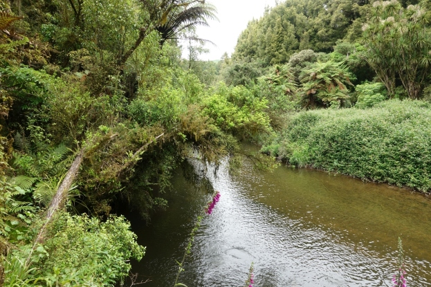
The track immediately enters native bush, continuing alongside the river and fairly close to it for most of the way. It is quite narrow in places, as well as close to the river bank.

There are a few steps along the track and short steeper areas that can be uneven and crossed by tree roots.

One of the older trees with some large vines hanging from it. The track passes immediately to the left of the tree.

The walk on the eastern side of the stream has a few short open areas through grass, blackberry and other weeds. In some places the vegetation had been trimmed to clear the track.

A short side track leads to some cascades on a small tributary stream, about 20 minutes from the start of the walk. The side track is shown as 2 minutes, and the continuation to a waterfall as 25 minutes.

The upper part of the cascades.

More hanging vines alongside the track, forming unusual shapes.

The track follows the river quite closely for most of the walk.


The waterfall next to the track. An old sign shows the river track as ending here, but the track continues on for another 500 metres or so to another swingbridge for continuing the walk on the other side of the river.

Looking across the stream to some limestone formations on the other side. The bridge is only a short distance on from here.

The track looks as if it continues on from here, with a side branch through grass to the swingbridge underneath the sign.

The track crosses over to farmland on the other side. As on the other bridge only one person at a time.

Looking from the swingbridge to a couple of memorial groves, and signs indicating the return track to the carpark on the right, and the continuation of Te Araroa Trail towards Pukeora on the left.

The information panel by the swingbridge. The time back to the carpark on either side of the stream is shown as 45 minutes, with a 5 to 6 hour 15 km walk to Mangaokewa Road.

The track initially passes through farmland, but is well marked with posts and orange triangles.

The track climbs up the hillside before entering bush again. Here looking back to the memorial groves and the swingbridge just to the left of them.

A stile and some fencing stops the farm animals from entering the bush along the track.

The track comes back down to the river and follows it back to the parking area.

The last part of the track opens up and passes through some areas of grass before reaching the parking area.

The exit from the track onto the parking area.

The GPS tracklog shows the route taken, with the river running between the southbound and the northbound legs. The carpark is at the northern end. The access road from SH30 is not shown. The total distance was about 5.4 km, with 2.7 km on each side of the river. The southbound leg took 45 minutes including time for photos.
Unfortunately I missed a turn on the northbound leg shortly after entering the bush from the farmland, and instead of retracing my steps when it was obvious that there was no track as I should have done, I continued through the undergrowth looking for the correct track. It didn’t help that there were some old triangular DoC markers along the way. The northbound leg should have taken 45 minutes, but ended up taking considerably longer. One day I hope to return to do the walk in the other direction to find where the missing turn is located.

The aerial image from Google Maps shows the same area as the tracklog.

The topographic map excerpt shows the track on the western side of the river, but not the one on the eastern side. There was a difference in elevation of about 30 metres between the lowest and the highest points on the track, with the lowest being at the carpark and the highest where about where the track enters the bush from the farmland.

The track was walked on November 24, 2019.
