Tag Archives: Rotorua

Mount Tarawera

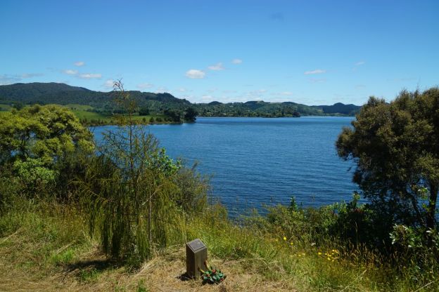
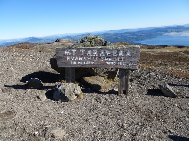
Mount Tarawera is a volcano in the Rotorua area, part of a chain of volcanoes stretching from Whakaari/White Island in the north, to Ruapehu in the south. It was the site of the largest and most deadly eruption in New Zealand in at least the last 250 years. It erupted in the early hours of June 10, 1886, causing the death of about 120 people and leaving a layer of ash and mud over a large area. Details of the eruption can be found on the New Zealand History web site, and on Wikipedia.

One of the tribes or iwi displaced from the area by the eruption, Ngati Rangitihi, are now guardians or kaitiaki of the mountain, and access to the summit is restricted. Ngati Rangitihi marae is located at Matata, and there are Ngati Rangitihi farmlands at Rerewhakaaitu, near the base of Mt Tarawera.

Continue reading

Utuhina Walkway, Rotorua

The Rotorua Walkway is a 26 km long walkway in Rotorua, broken up into 8 shorter sections. The walkways are described in the brochure Rotorua Walkways available on the Rotorua Lakes Council web site, under the Brochures heading. This walk covers the section named Utuhina in the brochure. It follows the Utuhina Stream for most of the way between Old Taupo Road near Pukuatua Street and the entry to Rotorua Tree Trust Centennial Park, on Kotuku Street, off Kiwi Street and Otonga Road. Two side tracks off the Rotorua Walkway, one of them joining Utuhina Walkway, were described in the previous post, Mangakakahi and Otamatea walkways, Rotorua.

The walkway passes through parks and reserves, with parts of it along urban streets. Some parking is available at Centennial Park at the southern end of the walkway, and on Mataatua Street at the northern end. There are no toilets by the walkway.

Continue reading

Mangakakahi and Otamatea walkways, Rotorua

The Rotorua Walkway is a 26 km long walkway in Rotorua, broken up into 8 shorter sections. In addition there are two shorter walkways branching off from the long walkway, following two tributaries to Utuhina Stream. The Mangakakahi walkway connects Sunset Road near Old Taupo Road and Pukehangi Road near Blomfield Street, and Otamatea walkway connects Pegasus Drive off Pukehangi Road and the Otuhina section of the Rotorua Walkway. The walkways are described in the brochure Rotorua Walkways available on the Rotorua Lakes Council web site, under the Brochures heading.

This walk through the Mangakakahi and Otamatea walkways was done as an anti-clockwise loop, starting and ending at the parking area on Mataatua Street, off Pukuatua St/SH30A. The start of Mangakakahi walkway is on Sunset Rd, about 1 km from the parking area. It is a combined walkway and cycleway. The middle part of the loop was a 1.4 km walk along Pukehangi Road from the end of Mangakakahi walkway, to Pegasus Drive where Otamatea walkway starts or ends. Total distance was 9.1 km, with a time of just over 2 hours.

Continue reading

Rotoma Bridle Track

Rotoma Bridle Track is a 1km long, easy, almost completely level, walking track running parallel to SH30 between the junction of Manawahe Road and SH30, and SH30 by Lake Rotoma’s Whangaroa Bay. SH30 is the main road between Rotorua and Whakatane. The track is an old bridle track and runs through mature native forest with tall stands of trees, including rimu and tawa, in the Rotoma Scenic Reserve. Information about the track is available on the DoC web site.

There is no parking or any other facilities at or near the track. Parking is easiest on Manawahe Road, entering the north-western end of the track a few metres from the junction with SH30.

Continue reading

TECT Park Radio Repeater lookout

The TECT All Terrain Park is located on Whataroa Road, off SH36 (Tauranga Direct Road) between Tauranga and Rotorua. Numerous activities are catered for in the park, with the area west of SH36 covering non-motorised activities, such as horse riding, mountain biking, hiking, model aeroplanes, shooting, and dog exercise. Details of the park can be found on their web site. Various maps can be viewed or downloaded from the maps page on the site.

The Te Rerenga Trail and Lost Tank tracks in the park have been covered in a separate post. This post covers the tracks to the radio repeater site with a lookout, with extensive views of the surrounding area. Continue reading

Te Rerenga and Lost Tank Tracks – TECT All Terrain Park

The TECT All Terrain Park is located about halfway between Tauranga and Rotorua, straddling SH36, and accessible from Whataroa Road. It is divided into two main zones, with various activities in each zone. The motorsports zone is located to the east of SH36, and the activity zone, off Weld Road, to the west of SH36. The park covers 1650 hectares of pine and native forest, with parts of the pine forest being clear felled at various times. Information about the park is found on the TECT All Terrain Park web site, including panoramic aerial photos of the park, maps, and details of activities.

There is a single dedicated hiking trail in the park, the Te Rerenga Tunnel Track, a loop track which starts and ends at the park entrance, where there is a parking area and toilet facilities. The track is about 3.2 km long, and is mostly an easy walk. Near the tunnel under SH36 there are steeper sections with steps on steeper parts and bridges across small streams. A torch is highly recommended for passing through the 36 meter long tunnel.

Continue reading

Kaharoa Kokako Track

The Kaharoa Kokako Track, also known as Kaharoa Track, Kokako Track, or Hollow Track, leads down from Kapukapu Road to the Onaia Stream. It is located about 30 km by road north of Rotorua, and 55 km south of Tauranga, off Tauranga Direct Road (SH36), via Kaharoa Road and Kapukapu Road. There is a parking area and information panels located by Kapukapu Road about 600 metres from the start of the track. At the track start there is only parking available for 2 or 3 vehicles.

The Kaharoa Kokako Trust was formed in 1997 as a charitable trust to ensure the long-term protection and survival of kokako at Kaharoa. Predator control is an ongoing task in helping to protect the habitat of the endangered kokako as well as other native birds such as kiwi in the Kaharoa Conservation Area.

Continue reading

Hemo Gorge Trail, Rotorua

The Hemo Gorge Trail, a 1.6 km long combined cycle and walkway, runs through Hemo Gorge alongside the Puarenga Stream and SH5/SH30 between Te Puia and the Waipa Mountain Bike park. The trail passes by remains from Rotorua’s early water supply. For part of the trail the walkway branches off and runs closer to the Puarenga Stream than the cycleway. The cycleway is part of the 48 km long Te Ara Ahi cycleway between Rotorua and Waikite Valley.

There is parking available at the southern Te Puia parking area, and toilets at the Waipa Mountain Bike park. Information about the trail can be found on the RotoruaNZ web site. At the Waipa end there is easy access to walking and cycle tracks through the Whakarewarewa Forest, including the walk to the Pohaturoa trig.

Continue reading

Lake Okataina Scenic Reserve – Ngahopua, Anaha and Kepa Tracks

There are several short walking tracks in the Lake Okataina Scenic Reserve. Three of these, all to the east of Lake Okataina Road, are accessible directly from Lake Okataina Road. The northernmost, Ngahopua Track, is a loop track with views to two crater lakes, Lake Rotongata and Lake Rotoatua, that traverses a few gentle slopes and climbs. The other two tracks, Anaha and Kepa, are on almost flat terrain and are mostly old vehicle tracks.

Lake Okataina Road branches off State Highway 30 at Ruato by Lake Rotoiti, north-east of Rotorua. Information about the walks can be found on the DoC web site, and a brochure with walks and hikes in the Rotorua area, including a map of tracks in the Lake Okataina area, can be downloaded from the DoC site. Parking is available where the tracks connect to Lake Okataina Road, or by the road leading to the Outdoor Education Centre. Toilets are available at Lake Okataina.

Continue reading

Lake Okareka Walkway

Lake Okareka Walkway is an easy walk of about 2.5 km each way alongside the edge of Lake Okareka from Acacia Road to Lake Okareka outlet. The first part of the walk consists largely of a boardwalk through wetlands, where many aquatic birds can be seen. The continuation from the end of the boardwalk to Silver Beach is along a wide, level track. The last part from Silver Beach to the outlet is narrower, and there are steps at both ends, with the track up to about 10 metres above the lake level. Return to Acacia Road by the same track.

There is a small parking area by Acacia Road at the track start, with no other facilities. However, there are toilets by the boat ramp and car park about 500 metres back along Acacia Road, and there are basic DoC toilets at Silver Beach. Bikes, dogs, and horses are not permitted on the walkway. The walkway start is about 12 km by road from the centre of Rotorua, with Okareka Loop Road branching off the road to Lake Tarawera.

Continue reading