Taitua Arboretum is a 20-hectare block of land mostly planted in a variety of trees and shrubs, both native and exotic. It was established, starting in 1973, by John and Bunny Mortimer who, in 1997, gifted the property to the people of Hamilton as an arboretum. About 3 km of walking tracks wind their way through the arboretum, with plenty of seats, shelter, lakes, poultry and ducks along the way. Bicycles are not permitted. Dogs are allowed but must be kept on a leash.
The arboretum is located in the Temple Heights area of Hamilton, at the end of Taitua Road, off Howden Road, and is signposted from SH23, the Hamilton to Raglan road. Taitua Road is shown on some maps as continuing on to Wallace Road, but this part is only open to walkers and cyclists. The arboretum is open daily from 8am until half an hour before sunset. More details are available on the Hamilton City Council web site. There is a parking area, with toilets and drinking water available by the entrance to the arboretum.
Till’s Lookout is located in a park in the Dinsdale area of Hamilton, within walking distance from the arboretum. On a clear day the lookout has almost 360 degree views of the Waikato district. The park also has an area where dogs can be exercised off-leash. It is directly accessible from Melva Street. The walkway/cycleway between Till’s Lookout and Taitua Arboretum forms part of Te Araroa trail, the 3,000 km long tramping trail between Cape Reinga and Bluff.
The entry to Taitua Arboretum at the end of Taitua Road, with a parking area on the left.

A very large old tree is located next to the entrance. Note the relative size of the vehicles parked adjacent to the tree.

There are toilets near the entrance, by the carpark. The large tree from the previous photo can be seen at the centre of this photo. There is a tap on the toilet building with UV-treated bore water suitable for drinking.

The track leading from the carpark to the arboretum. It’s a good idea to bring a map of the tracks, as not all the track junctions are clearly marked.

An information panel shows the layout of the arboretum, with the main track forming a loop, and with several shorter side tracks. The track to Till’s Lookout branches off in the lower right hand corner.

Shelter and seating is provided in several locations. The tracks are wide and there are no steps, although there are gentle slopes since there is a height difference of about 25 metres between the highest and lowest points of the main track.

Seating is also provided within the Redwood Circle. There are markers by some of the trees with their Latin and their common names, although it could be helpful with more of these.

A stand of tall and straight eucalyptus trees in one of the farm forestry areas.

Various varieties of monkey puzzle trees are within the ancient trees collection area.

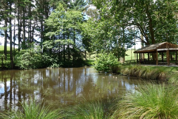
One of the lakes and a shelter between a farm forestry area and the Cryptomeria Walk.

Most of the track junctions are well marked, and there are also layout diagrams in several locations. The track over the bridge leads to the Bamboo Collection.

Part of the Bamboo Collection.

The track to Till’s Lookout branches off the south-eastern corner of the arboretum. This track leads up to Wallace Road, and can be used as an alternative entrance to the arboretum. Looking back to the arboretum near the start of the track the walkway/cycleway to Taitua Road is on the left, with the south-eastern corner entry to the arboretum on the right.

Looking in a northerly direction back at the arboretum from near the top of the climb up to Wallace Road. The range of hills in the background would presumably be from Hakarimata and further to the west.

The track back to the arboretum and Te Araroa Trail, seen from Wallace Road.

After a short walk along Wallace Road the walkway/cycleway and Te Araroa trail branches off and continues up the hill along a concrete path. The sign gives a time of 10 minutes from here to Till’s Lookout.

View from the lookout in a southerly direction, with Mount Pirongia to the right of centre, and Kakepuku left of centre. The top tip of the temple which lends its name to Temple Heights is just visible on the left hand edge of the flanks of Mt Pirongia.

From the lookout the tracks continue on to Melva Street and to Amanda Avenue.

The entry off Melva Street to Till’s Lookout, Te Araroa Trail, and the track to Taitua Arboretum. The dog exercise area is off to the left.

The GPS track log shows the routes followed, including both the arboretum and the branch off to Till’s Lookout. The arboretum track on its own was 2.3 km long, and took 40 minutes. The side track to the lookout and to Melva Street was a total of 4 km (2 km each way) and took 50 minutes. Note that not all the tracks in the arboretum were walked on this occasion.

The aerial photo, from Google Maps, shows the same area as the GPS map.

The tracks were walked on December 30, 2018.

Hi im wondering if there would be anyway to have a wedding here please.
LikeLike
My only connection to Taitua Arboretum is a single visit more than 3 years ago, and owning a copy of the book about trees written by John and Bunny Mortimer. You would have to contact the Hamilton City Council who now own the arboretum. You can find details on their web site:
http://www.hamilton.govt.nz/our-city/parks/parksandgardens/Pages/Taitua-Arboretum.aspx
Looking at that site I would guess that it would be limited to a photo location rather than a wedding venue.
LikeLike