Kopurererua Valley is a low-lying area about 5 km long covering an area of 300 hectares, with Kopurererua Stream running through it, from Tauriko at the southern end and Waihi Road at the northern end. The valley is bisected by Takitimu Drive, a toll road, which is part of SH29. The ridge on the western side of the valley has Cambridge Road running along the ridgeline, and the ridge on the eastern side has Cameron Road running along the ridgeline. The Whakapaewaka Bridge across Takitimu Drive, officially opened in early August 2018, allows walkers and cyclists to cross over from one side of the valley to the other, near the midpoint of the valley.
Combined walkways and cycleways run through the valley, with tracks leading to various side streets along the way. Bridges across Kopurererua Stream have also recently been constructed, and most of the tracks are wide with a gravel surface. Some are still grass areas which can be wet and muddy during winter and wet periods. Much of the valley consists of wetlands, and a boardwalk over parts of the wet area connects the ends of 17th Avenue and Faulkner Street.
The tracks can be accessed from various streets, both on the western and on the eastern side of the valley. These include Cambridge Road and Westridge Road on the western side, 16th Avenue, 17th Avenue, Laurence Street North, Faulkner Street, Wylie Street, and Marshall Avenue on the eastern. At the northern end there is access from Birch Avenue and Koromiko Street, and on the southern end from The Lakes subdivision. The only toilets at or adjacent to the tracks are by the BMX track, near Cambridge Road on the western side.
No web sites with coverage of all the tracks could be found, but there is a news item on the Tauranga City Council web site covering the opening of Whakapaewaka Bridge. A description of Kopurererua Valley Reserve is also on the council web site, including a link to a downloadable walking and cycling map. Currently the map does not show Whakapaewaka Bridge or several of the other tracks.
Walking almost all the tracks in the valley was done in four days, over four consecutive weekends. Many were walked in both directions, and some were walked three or more times. Total walking distance about 40 km and total time over 8 hours. There is almost no elevation change on most of the tracks, but there are steeper sections on some of the side street access tracks.
The first day started and ended at the north-western end of 17th Avenue, outside the Historic Village, day 2 and day 3 both started and ended at Wylie Street, and day 4 at Faulkner Street.
The skate park at the north-western end of 17th Avenue. The track on the right alongside the trees continues up to 16th Avenue.

The track from 17th Avenue and the skate park towards 16th Avenue. The climb up to 16th Avenue through the trees to the right is quite steep.

Looking from the track up to 16th Avenue. The skate park is partly hidden by leaves on the far right.

From 17th Avenue and the skate park the boardwalk heads towards Faulkner Street and on to Tauriko and The Lakes. Side tracks from the boardwalk before reaching Faulkner Street lead to Laurence Street North.

The parking area and shelter at the end of Faulkner Street,

A bridge crosses the Kopurererua Stream near the end of Faulkner Street. From here two tracks run in parallel on the edges of the stream all the way to Wylie Street. There are no other bridges over the stream between Faulkner Street and Wylie Street.

Kopurererua Stream with the tracks on both sides visible. A side track to the left leads up to adjacent streets.

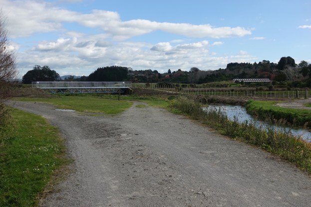
Approaching Wylie Street access there is a bridge across the Kopurererua Stream. The Whakapaewaka bridge across Takitimu Drive/SH29 can be seen on the far right.

From the bridge across the stream two parallel tracks continue on the sides of the stream heading towards The Lakes at Tauriko. The track branching off to the right leads to the Whakapaewaka Bridge across Takitimu Drive.

Whakapaewaka Bridge.

From the western end of the bridge a track to the left heads to Westridge Drive, while this one continuing straight ahead from the bridge leads to Birch Avenue with side tracks to Cambridge Road, the BMX bike park, and Townhead Crescent.

From the bridge across Kopurererua Stream near Wylie Street a track heads straight alongside a drain or stream back towards the city. Partway along this track there is an older bridge leading to the western track running alongside Kopurererua Stream.

A newer bridge at the end of the straight track crosses over Kopurererua Stream, allowing access to Faulkner Street and the track to Koromiko Street.

On the western side of Takitimu Drive, a track from Whakapaewaka Bridge leads to Westridge Drive. The last part of the track before reaching Westridge Drive is quite steep. This is looking back along the track towards Whakapaewaka Bridge, with Takitimu Drive on the right.

The access point to the track on Westridge Drive.

The newer track from Whakapaewaka Bridge leads towards the BMX track, which can be seen above the lake near the centre of the photo.

The BMX track is accessed by the road to the left, with the walkway/cycleway at the centre, with a small parking area and toilets on the right.

The access point on Cambridge Road to the BMX track and the walkway/cycleway. The road from here to the BMX track is tarsealed.

Another side track from the main track alongside Takitimu Drive leads to the same access point on Cambridge Road. Approaching the SH2 underpass and Birch Avenue the main track joins up with the straight track seen earlier, leading to The Lakes at Tauriko.

The track access point at the end of Birch Avenue. The track follows the graffiti-covered wall before branching to the left alongside Kopurererua Stream to Waihi Road, and to the left towards Tauriko and The Lakes.

The track along the rear of the buildings on Birch Avenue towards Waihi Road. On the other side of Kopurererua Stream is the track leading to Koromiko Street.

From the end of Birch Street there is also a track leading to Coventry Street, off Cambridge Road. To avoid the muddy first part of the track there is also an access point near the first building on the left side of Birch Avenue.

Looking from the track across wetlands towards Birch Avenue. The last part of the track nearest Coventry Street is rougher and steeper.

Most of the track towards Waihi Road behind the buildings on Birch Street follows a stopbank consisting of a concrete wall. It’s possible to walk or ride on either side of the wall.

The track crosses over McCord Avenue. There are steel steps on both sides of McCord Avenue, and from here there is also access to Koromiko Street and the track on the eastern side of Kopurererua Stream.

The access point on Waihi Rd between the bridge over Kopurererua Stream and Birch Avenue to the track running alongside Birch Avenue.

The track on the eastern side of Kopurererua Stream towards Koromiko Street. Access to the street is alongside the buildings on the far right.

The underpasses under SH2/Tamatea Arikinui Drive and Takitimu Drive do not have much headroom.

From near the end of Wylie Street there are two tracks heading towards Tauriko and The Lakes, one on each side of Kopurererua Stream. This one on the western side is mostly straight and level until it nears SH29A and Tauriko. The one on the eastern side, visible across the other side of Kopurererua Stream, rises to follow a more winding route. The two tracks are joined by a bridge across the stream, and continue to Tauriko as a single track.

A new bridge across Kopurererua Stream where the two tracks join before reaching Tauriko.

The narrow underpass under SH29A near its roundabout junction with Takitimu Drive, SH29, and SH36. The sign advises cyclists that there is a blind corner and they should use their bell.

On the southern side of SH29A looking towards The Lakes, with the Tauranga Crossing shopping centre on the far side of SH36 on the right.

From the track on the eastern side of Kopurererua Stream a side track on the far right leads up to Marshall Avenue, near the Barkes Corner roundabout.

Looking back along the track to Marshall Avenue across the wetland. The junction seen in the previous photo is in the gap between the small hills to the right of centre.

The track towards Wylie Street, Faulkner Street and 17th Avenue takes a winding path along the edge of the wetlands. There are some slight rises along the way.

The track returns to the Kopurererua Stream before following the stream on a grass track to the Wylie Street access point.

The GPS tracklogs show the routes followed on each of the 4 days. Together they cover almost all the walkways/cycleways in the Kopurererua Valley.
Day 1 started and ended at the north-western end of 17th Avenue, by the Historic Village. It followed the boardwalk to Faulkner Street, incuding a side track to Faulkner Street North, before taking the track on the eastern side of Kopurererua Stream to Wylie Street and short look down the track continuing on to Tauriko. Then back across the bridge by Wylie Street, over the new Whakapaewaka Bridge and a short way along the new track towards Cambridge Road. Back across Whakapaewaka Bridge and the straight track towards the city. Crossing over the bridge and along the grass area back to 17th Avenue. The grass area was once a cycleway/walkway, but is no longer much used or recommended, presumably after the boardwalk was opened. Total distance walked 12.2 km in about 2.75 hours.

Day 2 started and ended at Wylie Street, crossing the nearby bridge and the new Whakapaewaka Bridge, past the BMX park to Cambridge Road, along the main track and another side track to Cambridge Road, before continuing on to Birch Avenue, back under SH2 and SH29 to the two bridges over Kopurererua Stream on either side of Faulkner Street acess track, and the track following the western side of the stream back to the bridge by Wylie Street. Total distance 10.7 km in 2.25 hours.

Day 3 also started and ended at Wylie Street, first crossing the nearby bridge, then across Whakapaewaka Bridge and the track to Westridge Drive and back, following the track on the western side of Kopurererua Stream to Tauriko, then back along the track on the eastern side, including the side track to Marshall Avenue, to end at Wylie Avenue. Total distance 9.3 km, for a total time of 2 hours.

Day 4 started and ended at Faulkner Street, taking the track to Koromiko Street, along McCord Avenue to the bridge and the track to Waihi Street behind the buildings on Birch Avenue, then back along the same track to the western end of Birch Avenue, the track up to Coventry Street and back, and then to the bridge near the end of Faulkner Street. A short distance up Faulkner Street to to Laurence Street South, the walkway between the two ends of Laurence Street, the access track to the boardwalk, the boardwalk to 17th Avenue and the track up to 16th Avenue and back, before following the boardwalk and another access track to Laurence Street and back to Faulkner Street. Total distance 8.7 km with a time of 2 hours.

The aerial image, taken from Google Maps, shows the area covered by all the walks. Some of the tracks can be seen in the image, although the new bridges, including Whakapaewaka Bridge and it’s access tracks, are not shown.

The tracks were walked on August 11, 18 and 26 and September 1.

Where do I access the Puketoromiro Pa site track?
LikeLike
The track to the pa site is a side branch off the sealed walkway/cycleway through Kopurererua Valley. As stated it’s about 1.9km from the SH36/Lakes end of the valley, but there are numerous other access points to the valley itself.
LikeLike