Latham’s Hill Track, also called Lathams Track or Latham Track, is located by SH30 at Awakeri, about 17 km south of Whakatane, about 1.5 km west of the small township of Awakeri, and about 6 km south-east of Edgecumbe. One end of the track is accessible directly from SH30, where there is room to park 3 or 4 vehicles. It climbs through farmland and forest to Te Tiringa trig station at an elevation of 240 metres above sea level. It then continues along a ridgeline before descending steeply to end at the Awakeri Hot Springs. Walking along SH30 to the parking spot completes the loop in a clockwise direction. There is also parking available by the entrance to Awakeri Hot Springs, off SH30, so the walk can also be started and ended there.
Te Tiringa is the highest point of the Awakeri mountain range, and is of significance to local Maori as the landing place of Ngati Awa chief Tamarau.
The total walking distance for the complete loop is about 5.8 km, and the time taken was almost exactly 2 hours, including almost 10 minutes spent at the trig station. A short description of the track can be found on the whakatane.com web site, as well as on the Awakeri Hot Springs site. There are no public toilet facilities nearby, but it’s possible to pay an entry charge and take a soak at the hot springs pools and use the toilet facilities there.
The small parking area by SH30. The track starts with a climb over a stile just to the left of the parked vehicle, before climbing gently through farmland and patches of regenerating bush.

The sign on SH30 next to the stile and the start of Lathams Hill Track. The sign mentions two sign posted access points to Awakeri State Forest. No signs were seen on the track, and presumably there is no longer any state forest at Awakeri. The logo at lower left reads “New Zealand Forest Service”, which was abolished in 1987, but resurrected as Te Uru Rakau in May, 2018.

The track continues through farmland, to the right behind the stand of trees on the right.

Looking back down towards SH30, with Moutohora/Whale Island in the distance.

The track and SH30 encircle Ratahi quarry. Only a small part of the quarry is visible from the track, but the machinery working in the quarry can be heard along the way.

Most of the track appears to be an old farm 4WD or quad bike track, and has a gentle contour.

There are stiles crossing various fences along the track.

The track continues to the left after crossing the stile, but it joins up with the farm track which can be seen along the treeline above picture centre.

The track from SH30 to the trig station is well marked with orange triangle markers as used by DoC. The track continues to the right when it reaches the treeline.

Dogs are permitted on the track, but should be kept on a leash, as there are kiwi living in the forest. The track continues to the right after crossing the stile.

For some reason there are signposts instead of orange markers in a couple of locations. An old track may once have branched off to the left. The track starts getting steeper and rougher from here and on to the trig station.

Another location with signposts instead of triangular markers on the trees. The last part rises more steeply before reaching the trig station.

Te Tiringa trig station at 240 metres above sea level, with Moutohora/Whale Island in the distance, obscuring most of Whakaari/White Island which can just be seen in the dip between the whale body and tail.

The steam from Whakaari/White Island is hidden behind Moutohora/Whale Island, as is most of the island itself.

A panoramic view over Rangitaiki Plains, with Edgecumbe and Matata near the left edge, and Whakatane on the far right.

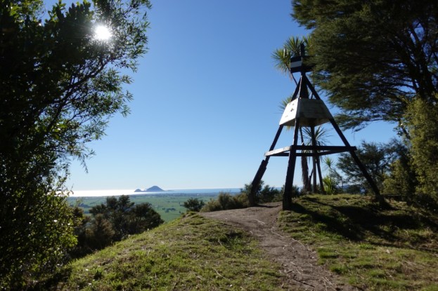
With the trig station off picture to the left, the track behind the twin trees on the left is the one from SH30. The one on the right heads down to Awakeri Hot Springs.

Near the start of the downward track there is a view to Putauaki/Mt Edgecumbe, with Mt Tarawera behind it in the distance to the right.

After a fairly easy walk along a ridgeline the track descends steeply through pine forest, with pine needles covering the track and making it slippery.

After the steep descent there’s a small fence to climb, before continuing to the right as a wider track with easy contour.

There are views across Rangitaiki Plains from a small clearing.

Looking back up the track (on the right) before the final level walk to Awakeri Hot Springs. On the left is a small lake with a fence across. Purpose unknown.

Looking towards SH30 from the edge of the small lake. The track continues through the gate and behind the tree to the right.

Approaching Awakeri Hot Springs. The track branches to the left, alongside the wooden fence.

The track starts by the steel gate leaning against the wooden fence. The sign to the right of the rubbish bin reads “Latham Track”. Awakeri Hot Springs office and shop is in the building on the left, and there’s room for parking on the grass area to the right.

The entry to Awakeri Hot Springs from SH30.

Seen from SH30, the entry to Ratahi quarry is behind the bare trees to the right of centre. The trig station is on the ridgeline visible behind these trees.

The GPS tracklog shows the route taken, starting from the parking spot at the top of the tracklog, and continuing in a clockwise direction. SH30 is about 20 metres above sea level and the trig station is 240 metres asl. The times and distances were:
SH30 parking spot to trig station: 2.3 km, 45 minutes
Trig station to Hot Springs: 1.9 km, 45 minutes
Hot Springs to SH30 parking spot: 1.5 km, 20 minutes.
Total: 5.5 km, 2 hours including 10 minutes at the trig station.

The aerial image from Google Maps shows the same area, with the quarry clearly visible.

The topographic map shows the terrain in the area. The track is not shown on the map.

The track was walked on June 28, 2018.

Thanks for this. It’s a thorough track description, and perfect for us to plan a day walk for our volunteer youth org. Well done.
LikeLike
Thanks for the comments, Peter. Much appreciated. Hope you have a good walk.
LikeLike
Outstanding track description and easy to find. Thanks!
LikeLike
Thank you. It’s good to know that people are finding the track descriptions useful.
LikeLike
The quarry is called Ratahi Quarry not Awakeri Quarry
LikeLike
Thank you for that. I see that Google Maps now has the correct name on the map. At the time this was written it was marked as Awakeri Quarries. Awakeri Quarry is a short distance further south-west. The text is now corrected, but this aerial photo has not (yet) been updated.
LikeLike