Nukuhou saltmarsh is a low-lying area located where the Nukuhou River enters Ohiwa Harbour. The tidal flow from Ohiwa Harbour brings in the salty water, going some way upstream at high tide, and forming a marshy area with a special flora and fauna. The saltmarsh is located adjacent to Wainui Road, between Ohope and Ohiwa, at Cheddar Valley. A lookout and a walkway alongside the road has been formed and is maintained by the Nukuhou Saltmarsh Care Group. Extensive predator control, mainly of rats and stoats, is also performed by the group, to allow other species to survive or flourish.
There is a small parking area by the junction of Wainui Road and Burke Road, providing easy access to the boardwalk leading to the lookout. The track directly off Wainui Road to the lookout is wheelchair-friendly, but the remainder of the walking tracks are not. There are no toilets near the track.
The walking track which runs alongside Wainui Road and Nukuhou River is about 2 km long, consisting partly of boardwalks, partly of narrow walking track, and partly of wider tracks. The contour is level, but parts of the track may be muddy, and some of the boardwalks do not have anti-slip mesh so can be slippery when wet. According to the information panels parts of the track may be under water at extra high tides.
There are numerous information panels alongside the track, as well as impressive tiles with sculptures of birds, made by Cheddar Valley pottery, located in an old dairy factory across Wainui Road from the saltmarsh. The Care Group appreciates donations to help with maintenance, and these can be left at the pottery. Information about the saltmarsh and the walk can be found in the flyer “The Nukuhou Saltmarsh” available for download from Bay of Plenty Regional Council web site. Information about the saltmarsh and other wetlands in the Bay of Plenty can also be found in the brochure “National Wetland Trust Trail Guide: Rangitaiki Plains and Ohiwa Harbour, Bay of Plenty Region”, which can be downloaded from the Wetland Trust web site, where it is titled as “Bay of Plenty Wetland Trail”.
The small parking area a few metres up Burke Road, with access to a picnic area where there are information panels and rocks with bird tiles, the boardwalk to a lookout, and the saltmarsh walking track.

The picnic area, with information panels and rocks with tiles and bird sculptures a few metres from the parking area.

The tiles show very realistic renditions of the various birds which are found in or near the saltmarsh. Unfortunately the traffic noise from Wainui Road tends to drown out the sound of bird calls along the walkway.

A few steps lead down from the picnic area to the walking track. The track to the left leads to the saltmarsh lookout, with the one on the right leading to Wainui Road and the walking track alongside Nukuhou River.

The entry off Wainui Road, on the corner of Burke Road, to the lookout and walking track.

The plaque by the track leading to the saltmarsh lookout.

The saltmarsh lookout, looking towards Wainui Road. Cheddar Valley is just to the right of centre.

The track alongside Wainui Road is quite narrow. Various plantings have taken place alongside the track.

Looking down Nukuhou River towards Ohiwa Harbour.

And in the other direction towards Cheddar Valley.

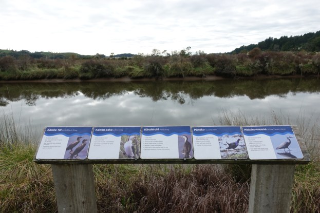
A small lookout with bird information panels alongside Nukuhou River.

Boardwalks have been built to cross the wetland areas of the track.

The walkway can be accessed from Wainui Road near the pottery, which can be seen on the right, on the opposite side of Wainui Road.

Whitebait or inanga spawning areas are found a short distance upstream. Apparently rats will eat the inanga eggs, so there are numerous bait stations by the track.

The south-eastern end of the track consists of a small loop, with the branch on the left following closer to the river, and the one on the right closer to the road.

The GPS tracklog shows the tracks walked, and places of interest. The total length of the track is about 2.1 km, including the track to the saltmarsh lookout. The return walk including the loop, back to the Burke Road parking area took 30 minutes, with the whole walk in both directions taking 1 hour and 10 minutes, including time for photos.

The aerial image, from Google Maps, shows the same area. The saltmarsh is clearly visible, as are parts of the walking track, especially at the south-eastern end.

The topographic map shows the area around the track and saltmarsh.

The track was walked on June 23, 2018.
Note: the current version of the saltmarsh brochure mentions some large macrocarpa trees and posts marking the site of the wharf used for shipping out produce from the dairy factory. The trees have been felled, and the posts have long since disappeared. A new version of the brochure with corrected information is due to be published shortly,
