Tag Archives: Katikati

MacMillan Reserve and Tamawhariua Reserve, Katikati

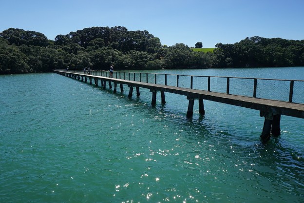
A parking area at the eastern end of Beach Road, Katikati, provides access to MacMillan Reserve to the north, and Tamawhariua Reserve and Coastal Walkway to the south. MacMillan Reserve provides walking and cycling access along the foreshore and then to the eastern end of Pukakura Road. Tamawhariua Reserve runs alongside the foreshore before heading back to Beach Road, ending on Beach Road about 500 metres from the carpark. There are toilets in the carpark, and a boat ramp off the end of Beach Rd.

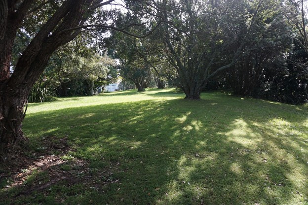
There appears to be very little information about the reserves, and although the Tamawhariua Reserve is mentioned very briefly in a Western Bay of Plenty District Council page about cycle and walking trails there were no signs on the route indicating it’s name. It is signposted as a public walkway and cycle way and is also open to mobility scooters. Dogs are permitted, but must be kept under control at all times. It appeared to be a popular route for dog walkers. Horses and motorcycles are not allowed.

Continue reading

Katikati – Haiku Pathway, Uretara/Yeoman Walkway

The Haiku Pathway in Katikati was constructed as a unique and lasting Millennium Project. Haiku poetry is carved into river stones along the pathway, in an area alongside the Uretara Stream. The project also included the Millennium Bridge, a footbridge linking the Highfields suburb with the town centre. At its construction it was the only Haiku Pathway in the Southern Hemisphere, and the largest display of boulder haiku outside Japan.

The pathway can be accessed from Highfields Drive, from the town centre, and from SH2 by the bridge over the Uretara Stream. From the Uretara Stream bridge a walkway continues northwards past the Uretara (or Katikati) Landing along the estuary and the waterfront to the Park Road Reserve at the northern end of Park Road. The walkway is known as the Uretara or Yeoman Walkway, and part of it as a Bird Walk, with sculptures of birds beside the walkway.

Continue reading

Kauri Point – Ongare Point

Note: The Kauri Point bush walks were closed in early June 2017 due to slips along the waterfront cliffs after heavy rain. More details on Bay of Plenty Times web site.

Kauri Point, Ongare Point, and Tuapiro Point are all located on the same peninsula in the Tauranga Harbour, north of Katikati. A walkway along the coastal reserve joins Kauri Point and Ongare Point, and continues along the full length of both small settlements. The walk can, of course, be started at either end.

Most of the track is on open land, with easy contour and little vegetation for shade. Only the southern end along the coastline at Kauri Point is steep in places and mostly under tree cover. At Kauri Point there is a 200-metre long wooden jetty which is a popular location for fishing.

Continue reading

Tuapiro Point

Tuapiro Point is a small, sandy spit in the Tauranga Harbour, across a channel from Tanners Point. A small pine plantation at the end of the spit has walking tracks through it, and horses can be ridden around the perimeter of the spit by the plantation. Recent developments have included a larger carpark and toilets next to the plantation. Some of the parking area is available for freedom campers.

The tracks through the plantation are short, and all level. A longer walk can be achieved by walking along the grass reserve on the waterfront. Continue reading

Tanners Point

The coastal walkway at Tanners Point, north of Katikati, follows the Tauranga Harbour coastline around the Tanners Point peninsula. It starts at the Tanners Point Reserve, and ends by the estuary at the western end of Tanners Point. The track rises and falls, with steps on some of the steeper parts. On the way it passes through a small area of private farmland, before descending to sea level through recently planted native vegetation. Old pohutukawa trees are present in several places along the track.

The track has a total length of about 1.6 km, making it 3.2 km and about 1 hour for walking in both directions. There is a parking area, including an area for freedom camping, at the end of Tanners Point Rd, by Tanners Point Reserve. Toilets are available nearby. Continue reading

Athenree Village

A short walkway along the foreshore of Tauranga Harbour runs the length of Athenree Village. It starts at the children’s playground on Waione Ave, a continuation of Athenree Rd, and runs along a grassy foreshore under large pohutukawa trees. There are views across the harbour to the Bowentown peninsula. Except around high tide the water views will mostly be across mudflats.

Parking is available by the playground and on the grass verge along Waione Ave. There are toilets across the road from the playground. Continue reading

Ananui Falls from Woodland Rd

Note: Please see the comments and the DoC web site, which state that the track has been closed to prevent the spread of kauri dieback disease.

Ananui Falls, in the Kaimai-Mamaku Forest Park, is a 106m high waterfall accessible from Woodland Rd, a few kms north of Katikati. Woodland Rd, previously known as Woodlands Rd since it was originally intended to be joined up with Woodlands Rd off Old Tauranga Rd south of Waihi, joins up with SH2 about 4 km north of Katikati. The parking area is at the end of Woodland Rd, with the last kilometre of the road being a narrow gravel road.

There are numerous stream crossings along the track, some of which may be difficult after heavy rainfall. Unfortunately there appear to be no good lookout points for viewing the falls, but the top of the falls are easily accessible from the track.

There are no facilities at the parking area, which is a large grassed area next to the junction of the Wairoa/Waitengaue Stream and Tamaki Stream. Information about the track is also available on the DoC web site.

Continue reading

Wharawhara Track – Wharawhara Rd to Cashmore Clearing

Wharawhara Track (or Wharawhara Tramway Track) follows an old tramline route alongside the Wharawhara Stream from Wharawhara Rd, near Katikati, to Cashmore Clearing in the Kaimai Range. It joins up with several other tracks at Cashmore Clearing, and another near the start of the track.

The track is almost 6km long, starting at an elevation of about 155m, and ending at Cashmore Clearing at an elevation of about 600m. The first part of the track has a gentle contour except where it crosses various streams or where gullies have washed away the original track, followed by a fairly steep zig-zag track before leveling out with a gentle rise to Cashmore Clearing.

Continue reading

Mount Eliza Mine and Summit

The Mt Eliza Mine Track connects the North South Track in the Kaimai Range to Thompsons Track, south-west of Katikati. Thompsons Track consists of two major parts: a road from SH2 south of Katikati to the boundary of the Kaimai Mamaku Forest Park, an impassable 4WD track crossing over the Kaimai Range to Thompsons Road, off Te Aroha – Gordon Rd on the western side of the Kaimai Range. The Mt Eliza Mine Track passes the old, abandoned Mt Eliza gold mine, with part of the track consisting of the pack track used to transport supplies to the mine. Continue reading

Aongatete Walking Tracks

There are several walking tracks starting near Aongatete Lodge, on a short access road near the end of Wright Rd south of Katikati. The tracks are in the Kaimai Mamaku Forest Park. One of the tracks provides access to the North South Track, which runs along almost the whole length of the Kaimai Range. The other tracks provide walks through regenerating native forest, and access to a popular swimming hole in a local stream.

There is a parking area on the lodge access road, and a toilet nearby. Access to the lodge itself, and the road from the parking area to the lodge, is for users of the lodge only, and should not be used for access to the tracks. Continue reading