Stoneham Walk, Hansen Walk, Prideaux Park, and Keith McKenzie Park are a contiguous set of recreation reserves in Kawerau with the Ruruanga Stream running through them between Valley Road, past Bell Street, to Tamarangi Drive (SH34). The Stoneham Walk reserve is quite separate from Stoneham Park, which is a reserve on Peter Lippa Drive. A walkway follows the Ruruanga Stream through the reserves, with bridges for the stream crossings.
There are several options for starting and ending a walk through the reserves, but the one recommended on the Kawerau Information web site starts on Plunket Street, across the road from the information centre. A brochure with a map can be downloaded from that web page. Parking is available off Plunket Street by the information centre, and toilets are available at the centre.
The map shows the walkway and eight bridges (seven of them numbered) crossing the Ruruanga Stream and a small tributary. The track shown does not extend to Tamarangi Drive and Keith McKenzie Park. The walk described here includes the track shown on the map, as well as a continuation to Keith McKenzie Park and back. Total distance walked was about 3.3 km with a total time of just under 1 hour. The brochure from the web site has descriptions of some of the bridges, including the stone bridge.

Looking across Plunket Street outside the information centre to Prideaux Park on the right, and the entry to the Ruruanga Stream walks between the bowling club and the building by the trees to the right of it. An information panel can be seen by the vehicle at photo centre with a tall wooden sculpture further to the right.

The information panel on Plunket Street by the corner of Prideaux Park. The map is slowly deteriorating and is not as detailed as the one shown above from the brochure, but the mounting frame is very impressive.

The tall wooden sculpture on Plunket Street by Prideaux Park, Kawerau was established in the early 1950s as a paper mill town, using wood sourced from the Kaingaroa Forest.

The first bridge to be crossed does not have a number on the map above. Turn left immediately on the far end of the bridge to continue on to Bell Street and Stoneham Walk. Turn right for a walk along the stream towards Tamarangi Drive and Keith McKenzie Park.

The walkway through the trees, to the left after crossing the first bridge. There is no formed track.

Bridge 4 on the map crosses over the stream with the pathway up to Fenton Mill Road and Bell Street at the far end.

Turn right onto Fenton Mill Road with only a few metres to walk until crossing over Bell Road. The stone monument and plaque on the other side of Bell Street mark the entrance to Stoneham Walk. Stoneham Walk is in memory of Roy Stoneham who was mayor of Kawerau from 1965 to 1983.

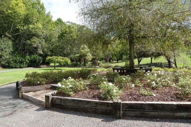
The rose garden. Bridge 5 from the map can be seen to the right. The track continues on the left, and the bridge will be crossed on the return part of the walk.

The stone bridge, with Ruruanga Stream visible on the right. Apparently the bridge is a popular wedding photo location. It consists of 35 tonnes of rock and 2 tonnes of cement, and took 340 man-hours to construct.

Approaching bridge 7, marking the end of the end of the walkway, and the return on the other side of the stream. Stoneham Walk reserve continues on to Valley Road.

The return walk continues on the other side of the stream before crossing over bridge 5, and then by the same route as before back to the first bridge crossed. Instead of crossing the first bridge again continue on alongside Ruruanga Stream to bridge number 3 from the map, seen here.

Cross over bridge 3, and continue to Tamarangi Drive which has to be crossed to access Keith McKenzie Park and bridges 1 and 2. Bridge 2 is on the left, but the track on the opposite side of Ruruanga Stream between bridge 2 and bridge 1 was so overgrown it was more or less impassable.

The stream, with bridge 1 shown here, is designated as a junior angler’s stream where children can fish for trout. The stream is periodically restocked with trout.

There is a parking area and picnic area in Keith McKenzie Park, accessible directly from Tamarangi Drive. From here turn back for the walk to Plunket Street and the information centre, but follow the edge of Prideaux Park instead of crossing over bridge 3.

The view to Putauaki/Mt Edgecumbe from the edge of Prideaux Park, alongside Ruruanga Stream. The information centre is adjacent to the cellphone tower just to the right of centre.

One end of bridge 3 can be seen to the right, with Ruruanga Stream between the trees.

The GPS tracklog shows the route followed. The information centre is on the far right, with Plunket Street curving around it. Total distance walked was about 3.3 km, with a total time of almost 1 hour. There are no steep inclines, but there are gentle inclines on both sides of Bell Street, and barriers have to be stepped across to cross over Tamarangi Drive.

The aerial photo, from Google Maps, shows the same area as the track log.

The tracks were walked on March 17, 2019.
