A link track connects the upper end of the Piako County Tramway track to Dog Kennel Flat junction adjacent to Mountain Road on Mount Te Aroha. From Dog Kennel Flat the road continues up to the summit of Mount Te Aroha and down to Tui Road by the Tui mines. From the junction it is also possible to take the steeper climb up the eastern side of Mt Te Aroha, or the Tui Saddle Track and Tui Track down to the Tui mines. Various other walking tracks also branch off nearby.
The link track, known as Te Aroha Link Track or Waiorongomai Link Track, also connects to Waipapa Track and Mangakino Pack Track. It is about 1.9 km long, and steep in places, mainly near the tramway end of the track. This walk was done starting and ending at Waiorongomai, turning around at Dog Kennel Flat.
This walk was done using the tracks giving the easiest walk to the upper end of the Piako County Tramway. For details about the tracks in the Waiorongomai Valley and the Mt Te Aroha tracks at Dog Kennel Flat please see the other entries on this site, especially Waiorongomai Valley – High Level Pack and Cadman Tracks, Buck Rock, Low Level Drive; Waiorongomai Valley – Piako County Tramway; and Tui Tracks to Mt Te Aroha Summit. The initial climb was to the top of Fern Spur Incline, then up the High Level Pack Track to the top of Butlers Incline, Piako County Tramway level 3 to the May Queen Incline, up the incline, and along level 4 of the tramway to the start of the link track.
The tracks up to the start of the link track have been covered in the other referenced posts, so will not be described in detail here.
The parking area at the end of Waiorongomai Road. There is also a basic DoC toilet, and track information panels nearby.

Work started on renewing parts of Fern Spur Incline some years ago. The top of the incline is now overgrown, and almost invisible.

The winch head at the top of Butlers Incline, near where the High Level Pack Track connects to level 3 of the Piako County Tramway. From here it is possible to continue up the pack track, but the walk along level 3 and up the May Queen Incline is easier and faster.

The tracks from level 3 of the tramway and up to Dog Kennel Flat have recently been cleared and vegetation cut back. Presumably this has been done by members of a tramping club, but thanks to whoever is responsible for the work. It is appreciated. Here the area by the compressor and pump on level 3 has been cleared.

Although the vegetation has been cleared from the track there is still the occasional small hindrance to walk around.

The May Queen Incline has also been cleared of most vegetation.

The winch drums at the head of May Queen Incline.

Level 4 of Piako County Tramway has a swing bridge crossing over a stream, with a short tunnel at the far end. Although the tunnel is short a torch or light is recommended, as the floor is uneven, there is a low ceiling in places, and due to a bend in the tunnel it’s not possible to look right through.

A short wooden bridge marks the end of Piako County Tramway. The link track starts at the far end of the bridge.

The old sign at the start of the link track. The track has presumably been shortened since this sign was written, as the walk to Te Aroha Mountain Road (Dog Kennel Flat) only took about 50 minutes.

The initial part of the link track is quite steep and rough, with rocks and tree roots on the track.

In between the steeper parts there are also gentler slopes with a well-formed track.

Some of the steeper slopes also have wooden steps to make the climb easier.

With tall vegetation on both sides of the track there are only occasional glimpses of surrounding hills. Mt Te Aroha summit is off to the right.

About a kilometre along the link track there is a junction with Waipapa Track heading off to the right, and the link track continuing to the upper left. The track levels out for some distance before and after this junction.

After another 100 metres or so there is another junction, with Mangakino Pack Track branching off to the right, and the link track continuing straight ahead.

At another junction there is an unmarked track on the right. Presumably this was the original track to Dog Kennel Flat, with a longer loop shown on the topographic map. This track has not been cleared, but is well formed and has obviously been used. The track at upper left continues directly on to Dog Kennel Flat.

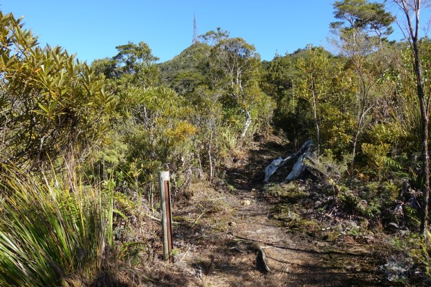
As the track opens up there are views to the summit of Mt Te Aroha, with its prominent mast.

The track gets steeper again as it approaches the Dog Kennel Flat junction, with more wooden steps.

The DoC sign at Dog Kennel Flat junction, at the top end of the link track. The track to the left is the steep walking track to the summit of Mt Te Aroha, a walk of about 35 minutes, and to the right is Dog Kennel Flat by the side of Te Aroha Mountain Road, and the upper end of Tui Saddle Track.

The view of Mt Te Aroha Summit from Dog Kennel Flat. The gravel on Mountain Rd can just be seen to the right.

On the return walk the afternoon sun was shining on some of the peaks of the Kaimai Range, to the east of Waiorongomai Valley.

The GPS tracklog shows the route taken. The same route was taken in both directions, although the GPS indicated a slight difference in distance for the upward and the downward legs. Total distances and times were:
Waiorongomai to start of link track: 4.9 km, 1 hour 50 minutes.
Link track to Dog Kennel Flat: 1.9 km, 50 minutes.
Total for upward leg: 6.8 km, 2 hours 40 minutes.
Total for downward leg: 6.4 km, 2 hours.
Total 13.2 km, 4 hours 50 minutes, including 10 minutes for lunch at Dog Kennel Flat.
From link track start to Waipapa and Mangakino Pack tracks about 1 km, and 30 minutes.

The elevation profile shows the upward leg, with the start at about 55 metres above sea level, and Dog Kennel Flat at about 770 metres. The two almost level sections from about 3 km to 5 km are level 3 and level 4 of Piako County Tramway. The link track starts at about the 5 km point. The High Level Pack Track is from about 0.75 km to almost 3 km, with May Queen Incline from about 4 to 4.5 km.

The topographic map excerpt shows a similar area to the GPS tracklog.

The aerial image, from Google Maps, also shows a similar area.

The tracks were walked on May 26, 2019.
