Mount Whakapoungakau is the highest point, at 758 metres, of the Whakapoungakau Range in the Lake Okataina Scenic Reserve. The summit is accessible as a side track off the Western Okataina Walkway, which is now a combined walkway and mountain bike trail. The walkway is accessible from the Lake Okataina and Lake Rotoiti end in several locations, and from the Lake Okareka end on Millar Road. This walk was done from Lake Okataina to the summit of Mt Whakapoungakau and return to Lake Okataina.
A short description of the Western Okataina Walkway can be found on the DoC web site, and all the tracks in the Lake Okataina region are described in a brochure available as a pdf file on the Rotorua Lakes Council web site. There is a link under the heading Brochures called Walking and hiking in Rotorua. Several of the tracks in the Okataina Scenic Reserve are also described in previous posts on this site, such as Lake Okataina Scenic Reserve – Ngahopua, Anaha and Kepa Tracks and Rongomai, Te Auheke and Tarawhai Tracks at Lake Okataina and Okataina Western Walkway – SH30 to Patotara.
This walk was done starting and ending at the shores of Lake Okataina, at the end of Lake Okataina Road which branches off SH30 at Ruato Bay by Lake Rotoiti. There are parking areas and toilets at Lake Okataina. The walk to the summit of Mt Whakapoungakau could be shortened by starting at the northern end of Waipungapunga Track on Lake Okataina Road, or from the Lake Okataina Outdoor Education and Recreation Centre. Both of these would also avoid an initial climb of about 90 metres on the Waipungapunga Track.
The total distance from the lakeside to the summit was 6.5 km, and the total time for the ascent was almost exactly 2 hours. The return walk was 1 hour and 40 minutes. The starting elevation is about 330 metres above sea level, and the summit is at 758 metres. There are a few shorter descents during the climb, but mostly it is a medium ascent, with some gently sloping or almost flat segments as well. The tracks were all in good condition and well marked.
Looking towards Lake Okataina from the southern end of Lake Okataina Road. The main parking areas and the toilets are on a short side access just visible behind the boat trailers.

Some of the parking areas on the short side access road at the end of Lake Okataina Road.

The access road also has the northern starting point of the Eastern Okataina Walkway, and the basic DoC toilet facilities.

The Waipungapunga Track starts about 250 metres along Lake Okataina Road from the lake edge. There is a small parking area suitable for only a few vehicles across the road from the track entry point.

The sign marking the southern end of Waipungapunga Track. From here it says there are 6km to the Whakapoungakau Trig at the summit of Mt Whakapoungakau.

Waipungapunga Track ascends in a zig-zag for the initial climb through regenerating native bush and reaches a junction with a track leading to the Western Okataina Walkway after about 1.7 km.

The last part of the track before the junction is almost level, and looks as if it has once been used as a forestry road.

At the junction Waipungapunga Track continues to the right for about 300 metres to exit onto Lake Okataina Road. This is the track used on the return walk. The track to the left continues about 1.3 km to the Education centre, but after about 365 metres of easy, almost level track there is another junction with the Western Okataina Walkway.

The track joining Waipungapunga Track and Western Okataina Walkway is almost level, and opens out to an area with no shade.


At the second junction the track continues ahead and veers to the right to the Education Centre, and on the left is the Western Okataina Walkway to Whakapoungakau Trig and Lake Okareka.

The track is well formed, with parts of it looking like old forestry roads. It passes almost entirely through regenerating native bush. In some of the steeper sections the track has been partly washed out and there are a few tree branches or trunks lying across the track.


Various marker pegs and triangular DoC markers show the track location. There are a few, short open areas as well as the regenerating bush. In some places pampas grass and other vegetation encroaches on the track.

The junction with the track on the right heading to the summit of Mt Whakapoungakau, and the track on the left being the 11 km long continuation of Western Okataina Walkway to Millar Road by Lake Okareka.

The sign shows 1.2 km to Whakapoungakau Trig, and 3.8 km back to the education centre.

The track to the summit of Mt Whakapoungakau starts out with a gentle downward slope.

The final climb zig-zags its way to the top of the mountain.

The transmitter mast with its power generating facilities and the trig station at the summit of Mt Whakapoungakau.

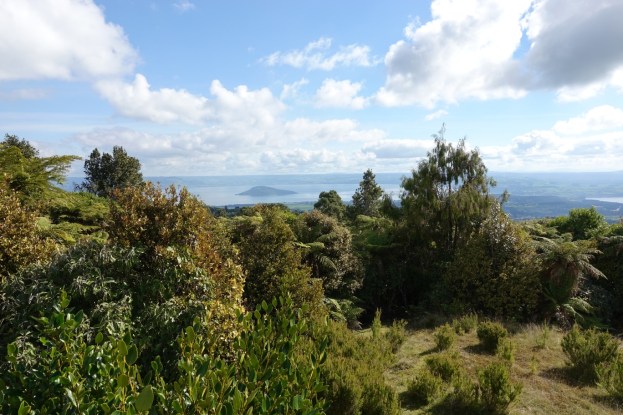
There are views over some of the Rotorua lakes, although vegetation growth limits those views. Here looking to Lake Rotoiti.

By climbing a metre of so up the trig station gives a view of Lake Rotorua with Mokoia Island clearly visible. A corner of Lake Rotoiti can be seen on the far right.

The return walk followed the same track until reaching Waipungapunga Track. It then continued straight along Waipungapunga Track for the 300m walk to Lake Okataina Road, and then along Lake Okataina Road back to the lake edge. Here is the northern end of Waipungapunga Track where it exits onto Lake Okataina Road.

An information panel by this track entry/exit point gives details about the Western Okataina Walkway.

Lake Okataina Road, looking towards the lake, with the Waipungapunga Track entry on the right, and the Kepa Track entry on the left. There are small parking areas by these entry points.

The GPS tracklog shows the route taken, starting and ending at Lake Okataina. The approximate times and distances were as follows:
Lake Okataina via Waipungapunga to junction 1: 1.9 km, 30 minutes
(of this the first 250 metres to point A was on Lake Okataina Road).
Junction 1 to junction 2: 365 metres, 5 minutes
Junction 2 to junction 3: 3 km, 1 hour
Junction 3 to summit Mt Whakaoungakau: 1.3 km, 25 minutes
Total from Lake Okataina to summit: 6.5 km, 2 hours.
The return from the summit to Lake Okataina, using Lake Okataina Road for the last leg from point B to the lake, was also 6.5 km, with a time of 1 hour 40 minutes. About 35 minutes was spent at the summit for a lunch break and talking to a couple of mountain bikers and a hunter who were also enjoying the fine day.

The height profile graph shows the elevation changes along the route. It should be almost symmetrical, but due to variations in GPS accuracy there are differences on the two halves. Lowest point at the lake is about 330 metres above sea level, and highest point at the summit is at 758 metres. The track is almost level between junction 1 and 2, and on either side of these junctions, for about 1 km. The two peaks at around 730 metres is at junction 3.

The topographic map excerpt shows the approximate track locations and the peak. Mt Whakapoungakau was also called Rangitoto Peak for a short time, apparently without proper consultation with the relevant iwi. However it was long enough for it to be marked as such on the official topographic map.

The aerial view, from Google Maps, shows about the same area as the other two maps. The summit of Mt Whakapoungakau was not marked by Google, but a close-up view of the image showed the location clearly.

The tracks were walked on May 5, 2019.
