Te Waiti Nature Trail is a short (800 metres, 30 minutes) walk through native forest in the Urutawa Conservation Area about 17 km by road south-east of Opotiki. The trail and conservation area are administered by DoC, and there is a very short description of the track on the DoC web site.
The track does not appear to be maintained or regularly used, there are almost no track markers, the entry point to the track has no signage, and the access road is a very narrow, winding gravel road that is not maintained by the local council. Only two or three vehicles could be parked by the entrance to the track without disrupting road traffic.
The track is accessed from Te Waiti Stream Road, also known as Te Waiti Valley Road, which continues on from Otara Road where it joins up with Pakihi Road at a bridge over Te Waiti Stream. The track entry is about 1.5 km from the junction of Otara Road, Pakihi Road and Te Waiti Stream Road. Te Waiti Stream Road continues on to Boulders Campsite and Bushaven. The campsite should only be accessed by 4WD vehicles, and the road itself is not suitable for large vehicles or vehicles with trailers. There are a couple of small fords to cross. At least they were small after a period with almost no rainfall.
The junction of Otara Road, Pakihi Road and Te Waiti Stream Road, with the Pakihi Road bridge on the left, Te Waiti Stream in the centre, and Te Waiti Stream Road continuing between the signage on the right. The road continues alongside the stream for about 1.5 km to the Nature Trail entrance.

The first ford is near the start of the road, with signage warning about unsuitable vehicles.

Weka can at times be seen wandering on the road. The road doesn’t get any wider, and there are very few places where two vehicles can pass.

The road enters the Urutawa Conservation Area.

The entry to Te Waiti Nature Walk, with the track heading between the vegetation just to the right of centre. It’s also possible to take a track to the left and walk the loop in a clockwise direction. This walk was done anti-clockwise.

The anti-clockwise direction was selected partly because it was the only track visible from the roadside entry, and partly because this triangle marker was the only one seen on the route and it pointed in the anti-clockwise track direction.

The track is partly overgrown, and partly covered in fallen vegetation, such as the nikau palm leaves seen here.

There are numerous steps on the track, mostly formed with half-round fence posts. The steps are mostly in reasonably usable condition.

Although some of the steps can be difficult to see, such as the ones heading up the hill to the left. The first part of the track zig-zags mostly in a gentle climb up the hillside.

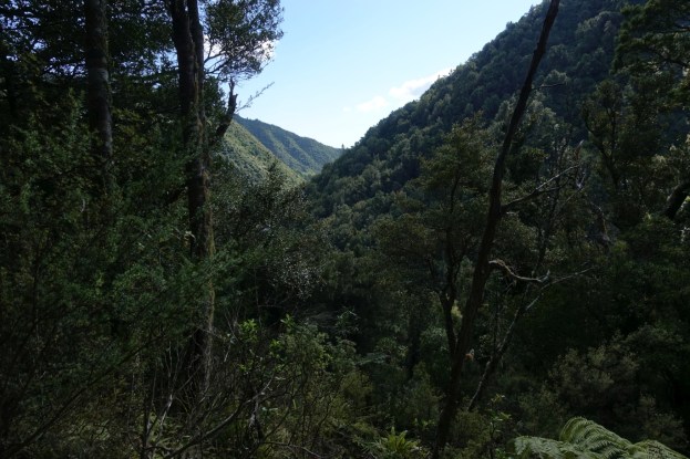
The track opens up for a time giving views down the valley in a northerly direction.

The track has a short section where it has been benched on the side of a steeper hillside. This allows for some views to the north.

There are other occasional peeps through the trees along the valley.

Some of the trees have had identification signs showing the names and details. This was the only remaining one still in place and still legible.

The Red Beech identification sign.

The southern or downhill part of the track is somewhat steeper, with plenty more steps than on the northern part. In places fallen trees lie across the track.

There are a variety of trees in the forest, but few of the visible ones appeared to be old and large. There was almost no birdsong and not much sign of bird life except for a couple of fantails seen along the way.

The end of the track by the side of the road. There is a quite large tree on the right, just by the exit.

The GPS tracklog shows the track walked. The track is about 800 metres long, and the walk took almost 30 minutes, including one wrong turn, and some time spent looking for the correct track. The track ascends from about 70 metres above sea level at the entrance, to about 125 metres at the highest point.

The topographic map excerpt shows a larger area than the GPS tracklog, with the location of the Nature Walk shown, as well as the road from the Otara Rd/Pakihi Rd junction and the location of the Boulders Campsite.

The aerial view, taken from Google Maps, shows the same area as the topographic map, with the location of the Nature Trail and Boulders campsite also shown.

The track was walked on April 20, 2019.

Kia Ora
My name is Roberta Waiapu
I am trying to make contact with any farmers in Te Waiti farms next to Herema road Opotiki
LikeLike
Sorry, I can’t help you with that.
LikeLike