Author Archives: nzartig

Putauaki (Mt Edgecumbe), Kawerau King of the Mountain race

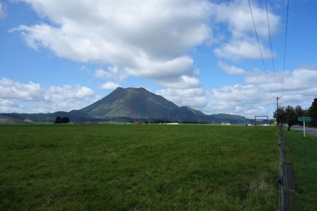
Putauaki (Mt Edgecumbe) towers 820 metres above the township of Kawerau at the southern end of the Rangitaiki Plains. The town was built in the early 1950s for to support the new pulp and paper mill being constructed at the same time. The Kawerau King of the Mountain race, a race from the town to near the summit of Putauaki and back, has been held every year since 1955. Information about the race, with entry forms and race results can be found on the Kawerau King of the Mountain web site.

Access to the mountain is now controlled, and a permit is required to climb the mountain. Due to safety concerns it is necessary to climb in groups of at least 4 people, and the office issuing the permits is only open on weekdays. See the Kawerau Online web site for more details of the mountain and the procedure required to obtain a permit.

Note: According to an article in The Beacon on July 15, 2022, permits to climb the mountain will not be issued until a safety review has been done and any required work completed.

Continue reading

Ruahihi Canal walkway/cycleway

Ruahihi Canal was constructed in the late 1970s and early 1980s to lead water from Lake McLaren and the Wairoa River to the Ruahihi Power Station adjacent to SH29. The canal is about 2.5 km long, with water then being fed into penstocks for the final part of the journey to the power station. The penstocks are mainly underground, but the single penstock pipe can be followed from the end of the canal as far as Gunga Lane and Ruahihi Road. At some point the single pipe is split into the two which can be seen alongside SH29, across the road from the power station.

On most days the Wairoa River from McLaren Falls to the power station is only a trickle, but on some weekends the control gates are opened and the river returns to a normal level during the day. The river is popular for white water rafting.

Continue reading

Omokoroa Peninsula

There are several walks on the Omokoroa Peninsula, with the most popular being a short walk from the Domain, through the Gerald Crapp Historic Reserve and past the Wai-Huri Pa site, to Bramley drive. A much longer walk of about 9 km continues from Bramley Drive and along Hamurana Road to a coastal walk alongside the Omokoroa Golf Course, across the peninsula to the the Cooney Reserve and heading back along the waterfront to the Domain. The coastal walk alongside the golf course is not passable at high tide, but there is an alternative track along the northern and eastern side of the golf course.

The longer walk is not particularly well marked, especially around the golf course. No markers show where to leave the waterfront and head alongside the golf course up to Kayelene Place. The walks are described in a booklet available for download from the Western Bay of Plenty District Council web site.

Continue reading

Waihi to Waikino loop – rail and walk/cycle

Until the original Martha gold mine in Waihi closed in the early 1950s the ore was transported by rail to Victoria Battery at Waikino in the Karangahake Gorge. This rail line ran alongside the left bank (southern side) of the Ohinemuri River. Part of the Hauraki Rail Trail now follows the route taken by this railway line. On the right bank of Ohinemuri River the New Zealand Rail railway line between Waihi and Paeroa followed alongside State Highway 2. The railway line was closed when the Kaimai Rail Tunnel was completed, but the line between Waihi and Waikino is now used by the Goldfields Historic Railway to carry passengers on the 30-minute journey between the two end points.

Goldfields Railway will also transport bicycles, so it is possible to take the train in one direction, and then walk or cycle in the other direction. Here the rail journey was taken from Waihi to Waikino and the walk done on the Hauraki Rail Trail cycleway/walkway from Waikino back to Waihi.

Continue reading

Waiorongomai Pylon Peak Track

The Pylon Peak Track in the Waiorongomai Valley was opened up in 2015 and currently does not appear on the DoC web site or signs in the area. The track branches off the Low Level Pack (or Low Level Drive) Track near the end of Waiorongomai Road, crosses the Waiorongomai River, climbs to a ridgeline which it follows before climbing quite steeply to the Pylon Peak and joining up with the Kaimai Ridgeway Track (formerly the North-South Track).

There are still a few remains of the steel power pylons which were used for the power line linking the Horahora hydro-electric power station with the Waihi gold mine and Victoria Battery in the Karangahake Gorge. The power station was the first large power station on the Waikato River and on the North Island, built in 1913 and commissioned in 1914. The power station was sold to the Government in 1920, expanded, supplying power to Paeroa and further afield to Cambridge, Hamilton and Auckland, before being submerged by Lake Karapiro after the Karapiro Dam was completed in 1948.

Continue reading

Broken Hills, Hikuai

Broken Hills at Hikuai was a gold mining area in the late 19th and early 20th centuries. The mining settlement of Puketui alongside the Tairua River had about 200 residents by 1912, but production at the mines declined shortly afterwards, and only small-scale mining continued until 1923. A permanent settlement at the current DoC campsite at the end of Puketui Valley Road was planned but not built due to the decline in gold production. There are only a few relics left from the mining days, and no remains of the settlement.

The walkways in the Broken Hills Gorge can be accessed from either Puketui Valley Road or Puketui Road. There is no road connection between these two, and the Third Branch Stream must be crossed for all access from the end of Puketui Road. This stream can be fast flowing and difficult to cross with dry feet.

Continue reading

Tauranga / Historical Inner City + Waikareao

Several historical sites are easily accessible in the Tauranga City Centre, and a loop walk around the city can include those sites as well as other points of interest. A booklet published by Tauranga City Council previously described the walk as “Tauranga / Historical Inner City”. In later editions, as well as the online edition, it does not show the loop walk, and calls it Tauranga/CBD.

The historical sites are The Elms Mission house in Mission Street, Mission Cemetery, Monmouth Redoubt, Te Awanui Waka, and Wharepai Domain. Other points of interest include the Rose Gardens, Robbins Park, The Strand reclamation, and the Hairy Maclary sculptures.

Continue reading

Waikareao Estuary Walkway

Waikareao Estuary Walkway consists of walking and cycling tracks and boardwalks around the estuary close to central Tauranga and Otumoetai. It is accessible from several locations, and several side tracks lead to and from the walkway. On the western side of the estuary the walkway passes over mangrove tidal zones, and through parks and reserves. On the eastern side the walkway follows alongside Takitimu Drive, with the option of crossing over the busy road to more peaceful and green areas on the other side.

This walk was done in an anti-clockwise direction, starting and ending at the carpark on Maxwells Road, near Chapel Street, and following the track on the western side of Takitimu Drive between Waihi Road and Chapel Street. The Chapel Street part of the walk follows the footpath alongside the road. Total distance was almost 9 kms with a total time of almost 2 hours.

Continue reading

Gordon Carmichael Reserve

Gordon Carmichael Reserve is a 60-hectare reserve located between Bethlehem and Brookfield suburbs in Tauranga. The reserve is used as a stormwater reserve, with ponds and wetlands, extensive areas of native plants, and several kilometres of cycleways and walkways, accessible from several streets in the area. Over 200 metres of boardwalk have been constructed in the wetlands areas. A small carpark is located on Carmichael Road, adjacent to toilets, a playground, and an outdoor classroom. Access to the carpark is closed at night.

Access to the northern end of the reserve off Princess Road has a sign indicating that this is York Park, but there is no indication of the location or extent of the park.

Continue reading

Yatton Park to Fraser Street Reserve

Yatton Park, in Parkvale, Tauranga, was established by John Alfred Chadwick in the 1860s after having bought land confiscated in the wars between Maori and the British. He named the location Yatton Estate, and planted many of the trees still standing in the park. Also known as Tutarawananga it is the location of the first school in New Zealand, established in the 14th century to train tohunga (carriers of knowledge, priests or wise men).

Yatton Park is accessible directly from Fraser Street, and near the entrance there are parking areas and toilets. From Yatton Park a track leads down to the Waimapu Estuary, and along the estuary to Fraser Street by the Fraser Street Reserve. A side track leads up to Esk Street and continues on to Fraser Street by number 330.

Continue reading