Author Archives: nzartig

Wentworth Falls

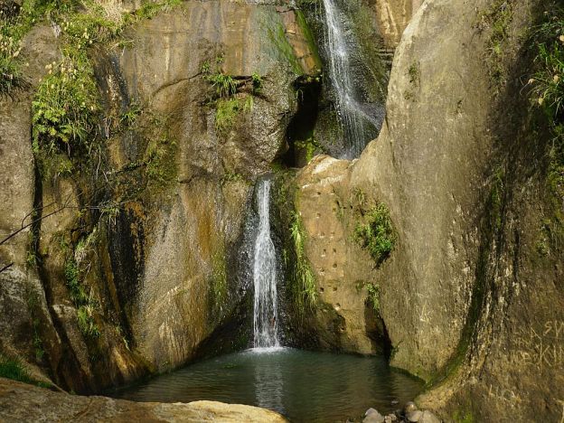
The Wentworth Falls are accessible from the end of Wentworth Valley Rd near Whangamata on an easy walking track. The falls consist of two drops of about 20 metres each, and can be seen from a viewing platform close to the Wentworth Falls Track. Another track near the end of Wentworth Valley Rd leads past two old gold mine adits or entrances.

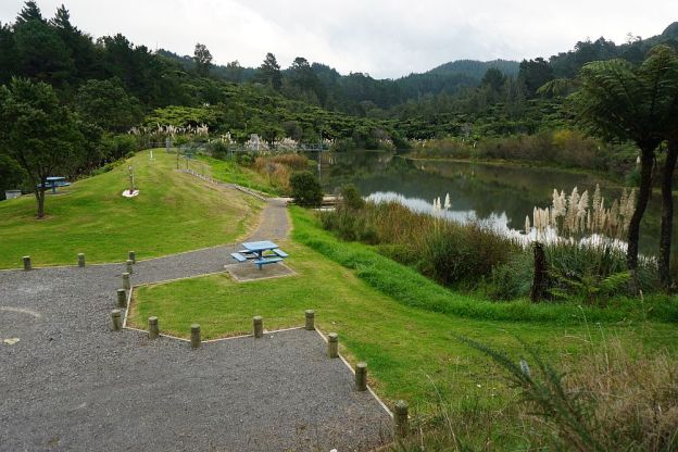
There is a DoC campground at the end of Wentworth Valley Rd, and the track starts by the campground. A public parking area is available nearby.

Continue reading

William Wright Falls

William Wright Falls is a 28m high waterfall in the Orokawa Scenic Reserve, accessible only by a tramping track from Orokawa Bay. The Orokawa Stream runs down the cliff face before plunging into a small pool partway up the face, and another fall into the stream bed. The track and falls should not be accessed during and immediately after heavy rain, as the track follows the stream bed for most of the way. It was closed for a year or more after the original track was washed away after heavy rain.

The track is a side track to the Orokawa Bay to Homunga Bay track, and can be done as part of that walk, adding betweeb an hour and 90 minutes to that walk. Or it can be combined with a walk from Waihi Beach to Orokawa Bay for a shorter time and distance.

Continue reading

Pohutukawa Park track at Waihi Beach

The Pohutukawa Park track runs through the forest in the hills at the northern end of Waihi Beach, between the beach and the old Waihi Beach water supply reservoir. Both ends of the track are close to residential areas. Dogs are allowed on this track, which is not administered by DoC.

The track is not very long, but has a number of steeper sections with steps. The track has small, white, rectangular track markers instead of the orange triangular ones used on DoC tracks. The track is also accessible from Pohutukawa Park. There are no great views from the track itself, but there are pleasant picnic spots near Pohutukawa Park and by the reservoir.

Continue reading

Orokawa Bay and Homunga Bay

Sandy beaches at Orokawa Bay and Homunga Bay, north of Waihi Beach and within the Orokawa Scenic Reserve,, are only accessible from land by walking tracks. The shortest access to Orokawa Bay is from the northern end of Waihi Beach, and to Homunga Bay it is from the end of Ngatitangata Rd, east of Waihi. The track from Ngatitangata Rd is steep and passes through private farmland. There is also a coastal walking track between Orokawa Bay and Homunga Bay, which was reopened in early 2014 after being closed for some time due to slips.

This post covers the coastal walk from Waihi Beach to Orokawa Bay and Homunga Bay, returning the same way.

Continue reading

Rainbow Mountain – Maungakakaramea

Rainbow Mountain – Maungakakaramea is located adjacent to SH5 and SH38 between Rotorua and Taupo. There is a parking area just south of the SH5/SH38 intersection, across the road from a rest area by Lake Ngahewa Recreation Reserve. The mountain is located in an area with geothermal activity, with Waimangu, Waiotapu and Waikite geothermal areas nearby. The mountain itself has a number of themal vents, and steam can be seen rising in numerous locations. Continue reading

Tuahu Kauri and Sentinel Rock

Although it is now considered too dangerous to climb Sentinel Rock, a large rocky outcrop in the Kaimai Mamaku Forest Park, it is still possible to view the rock and surrounding valley from a nearby lookout. There are also views to the Pacific Ocean and parts of the Bay of Plenty.

The track to the lookout starts at the end of Hot Springs Rd, just south of Katikati. The Tuahu Track and Tuahu Kauri Loop Track lead past two of the largest kauri trees in the Western Bay of Plenty, to the start of the Sentinel Rock Track.

Continue reading

Ngamuwahine and Ngamuwahine Loop Tracks

The Ngamuwahine and Ngamuwahine Loop Tracks on the northern slopes of the Kaimai Ranges in the Kaimai Mamaku Forest Park are accessible from the end of Ngamuwahine Road, off SH29, about 25km south of Tauranga. Ngamuwahine Road, about 3km long, is gravel, winding, and only about 1 vehicle width most of the way. So meeting with other traffic usually means one of them reverses to the nearest suitable passing spot.

Tauranga Intermediate School administers an outdoor education facility, the Ngamuwahine Outdoor Education Lodge, at the end of Ngamuwahine Road. There is a large grass parking area and picnic area at the end of the road, by the entrance to the lodge and the start of the track. But there are no toilet facilities on or near the track.

The tracks pass through regenerating native forest, with a number of pine trees in between. All the tracks are under tree cover, so will stay moist for most of the year.

Continue reading

Nga Tapuwae o Toi – Burma Rd to Whakatane

The Nga Tapuwae o Toi (or Footsteps of Toi) track continues on from Burma Rd to Whakatane at the lower end of Mokorua Gorge. See this post for the part from Ohope to Burma Rd. Refer also to that post for pointers to DoC web site information about the track.

The Whakatane end of the track is not actually marked as the Toi track, but there is a sign on White Horse Drive calling it the Mokorua Walk. There are apparently no markers at the lower gorge end with the track name, or any other information about the track.

There is room for cars to park at the start on Burma Rd, and a car park at the Whakatane end, but no toilet facilities anywhere on or close to the track. Dogs and bicycles are not permitted on this track.

Continue reading

Nga Tapuwae o Toi – Ohope to Burma Rd

Nga Tapuwae o Toi, or The Footsteps of Toi, is a loop track between Whakatane and Ohope. This post covers the track between Ohope and Burma Rd, as well as the Fairbrother Loop Walk. Two previous posts cover the coastal part of the track, also known as the Kohi Point Walkway, and can be found here and here. There is a description of the various parts of Nga Tapuwae o Toi on the Doc web site.

Efforts are being made to maintain a population of kiwi in the forest area, and other threatened native birds have also been released in the reserve, including the NZ robin. To maintain and improve the birdlife requires a constant pest eradication program.

The walk starts at the Ohope end near the junction of Ohope Rd, West End Rd, and Pohutukawa Ave, as you enter Ohope on the main road from Whakatane (Ohope Rd). There is a parking area and toilet facilities a short distance down West End Rd.

Continue reading

Te Tapui Loop Track – Maungakawa

The Te Tapui Scenic Reserve includes the two peaks of Te Tapui at 492m and Maungakawa at 495m. The Te Tapui Loop Track to the summit of Maungakawa starts at Piakonui Rd, west of Matamata, northeast of Cambridge and southeast of Morrinsville. It can be walked in a clockwise or anticlockwise direction, although the DoC description recommends the anticlockwise direction.

However, the times and distances on the DoC site do not entirely agree with my experience. The distance is close to 6.5km measured by GPS instead of 4km, and the time of 3 hours should be ample even with a long break at the summit.

Continue reading