Author Archives: nzartig

Dickey Flat to Karangahake loop

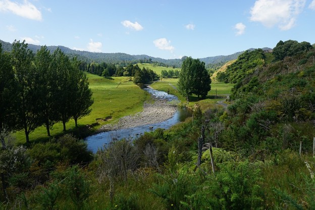
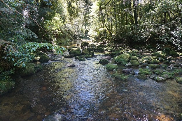
The Dickey Flat campsite, administered by DoC, is located on the banks of the Waitawheta River in the Karangahake Gorge and the Kaimai Mamaku Forest Park. Located at the end of Dickey Flat Rd, off Kennedy Rd and Waitawheta Rd, it is a popular campsite in the summer, with swimming holes and trout fishing spots easily accessible.

Two walking tracks, which can be walked as a loop walk, connect Dickey Flat and Karangahake. The south-western track passes through regenerating native bush, with the north-eastern track following the Waitawheta River and the historic Waitawheta pipeline. The total loop has a length of just over 10km. It can be walked in either clockwise or anti-clockwise direction, and starting at either Dickey Flat campsite, or by SH2 at Karangahake.

Continue reading

Dean, Mangakino Pack, Daly’s Clearing and Waitawheta Tramway Tracks

A loop walk in the Kaimai Forest Park, starting and ending on Franklin Rd near Karangahake, uses the Dean Track, part of the Mangakino Pack Track, Daly’s Clearing Track, and part of the Waitawheta Tramway Track. At the Franklin Rd end the walk passes through privately-owned farmland. There is a small parking area on Franklin Rd, but no toilet or other facilities.

The walk consists mainly of tracks with an easy contour, although there is an elevation difference of about 240m between the lowest and highest points. More information about the loop walk can be found on the DoC web site, although the information there does not quite agree with the GPS data. The GPS shows a total distance of about 9.2 km, instead of 7.5km.

Continue reading

The Redwoods – Tokorangi Pa Track

Tokorangi Pa Track is the longest of the three longer walking tracks through the Whakarewarewa Forest. As with the other two, the Pohaturoa Track and the Quarry Track, it starts and ends at the information centre on Long Mile Road, off Tarawera Road. The start of the tracks is covered in the posts with those two tracks, and information about the tracks can be found on the Redwoods site.

The track has a posted length of 11.5 km, with an estimated time of 3 hours 30 minutes to complete the walk. It passes through various forest areas, with several different varieties of trees, but there is no obvious sign of the actual Tokorangi Pa site along the track. A significant part of the track does not have any or only partial shade from trees. The track consists of a loop, marked for walking in a clockwise direction.

Continue reading

The Redwoods – Quarry Track

The Quarry Track in the Whakarewarewa Forest is a loop track of just over 4.5 kms starting and ending at the Redwoods information centre on Long Mile Road, off Tarawera Road.

For information about the parking and other facilities at the information centre, and the start of the Quarry Track, see the previous post about the Pohaturoa Track.

Continue reading

The Redwoods – Pohaturoa Track

Whakarewarewa Forest, near Rotorua, is a production forest with tracks for walkers, mountain bikers and horse riders open to the public. About 12 hectares of the forest was planted in Californian redwoods (sequoia sempervirens) in 1901, About 6 hectares of these plantings remain, with some of the trees having reached a height of more than 70 metres. Numerous other tree varieties were planted in the forest at about the same time, but few of these remain today. The forest covers 5600 hectares.

The forest walks all start at the information centre at The Redwoods, on Long Mile Road, off Tarawera Road. The mountain bike trails are accessed from Waipa State Mill Road, off SH5 between Rotorua and Taupo, where there is a large parking area. Toilet faciities are available at both these locations, with shower facilities at the Waipa State Mill Road location.

Continue reading

Rapurapu Kauri Track

The Rapurapu Kauri Track in the Kaimai Mamaku Forest Park is accessible directly from SH29 the Waikato side of the Kaimai Range. The track leads to 3 large Kauri trees near the southern limit of their natural occurrence. On the way the track crosses the Rapurapu Stream 8 times. The stream crossings may not be possible after heavy rain.

The first 750 m or so of the track goes through recently cleared pine forest, before entering the regenerating native bush area in the Forest Park. The same track is used in both directions, for a total of about 6 kms, but with only about 30 m in height difference between highest and lowest points.
Continue reading

Wharawhara Track – Wharawhara Rd to Cashmore Clearing

Wharawhara Track (or Wharawhara Tramway Track) follows an old tramline route alongside the Wharawhara Stream from Wharawhara Rd, near Katikati, to Cashmore Clearing in the Kaimai Range. It joins up with several other tracks at Cashmore Clearing, and another near the start of the track.

The track is almost 6km long, starting at an elevation of about 155m, and ending at Cashmore Clearing at an elevation of about 600m. The first part of the track has a gentle contour except where it crosses various streams or where gullies have washed away the original track, followed by a fairly steep zig-zag track before leveling out with a gentle rise to Cashmore Clearing.

Continue reading

Black Hill Walkway – Waihi

Black Hill in the Ngatikoi Domain (or Black Hill Reserve) is a 225m high hill on the outskirts of Waihi. The surrounding area contains mountain bike tracks as well as walking tracks. There is an easy, formed track around the base of the hill, and a steeper and rougher unformed track to the summit of Black Hill. Primary access to the area is from the end of Clarke Street, but it is also possible to access via walkways from Gilmour Reserve on Gilmour Street, Baker Street (off Clarke Street), and Morgan Park (off SH25/Barry Rd).

The walk can be done together with the Martha Mine Pit Rim Walkway, but in this case it was done starting at Gilmour Reserve and walking anti-clockwise around Black Hill. On the way back to the Gilmour Reserve the Mill Stream walkway to Barry Rd was also included.

Continue reading

Martha Mine Pit Rim Walkway – Waihi

The Martha Gold Mine in Waihi was originally an underground mine which closed in 1952. It was reopened as an open pit mine in 1988, in the centre of Waihi township. The extent of the mine is limited by the residential and commercial areas surrounding it. Currently the pit mine is closed, but underground mining is continuing in Waihi. When the pit mine finally closes the plan is to create a lake for recreational use.

As part of the mining consent the owners of the mine have to provide certain facilities, such as the Pit Rim Walkway which is a 4km long, easy walking track around the perimeter of the mine pit. There are various lookouts and historic remnants from the original mines in the area.

Continue reading

Pukeatua

Pukeatua peak, a 753 m high mountain peak, is located in the Maungatautari Ecological Island, within the Sanctuary Mountain Maungatautari enclosure. Pukeatua is the second-highest peak within the sanctuary, and the only one with a view. Maungatautari is the highest at 797m, but due to vegetation there are no views from here. The mountain sanctuary is surrounded by a 47 km long predator proof perimeter fence, protecting the many species of native birds and other animals from predators such as stoats, rats, cats, dogs, possums, rabbits and other mammals.

Within the 3,363 hectare forest there are three other special enclosures with an extra perimeter fence around them. These are the northern enclosure, the southern enclosure, and the tuatara enclosure. The last two of these are near the visitor centre at the end of Tari Rd, off Arapuni Rd. The northern enclosure is near Hicks Rd, at the northern end of the forest. There is an extensive trapping program within the sanctuary, and warning systems to alert when any breaches of the fences may occur.

Continue reading