Hapuakohe Walkway in the Waikato consists of two parts. The northern part connects North Road (off SH27) and Ohinewai Road (also off SH27) along Hapuakohe Range. The southern part connects Ohinewai Road and Mangapiko Valley Road, passing by Maungakawa trig station on the way. The northern part is signposted as an 8-hour walk, with the southern a 6-hour walk. Information about the track can be found on the DoC web site. The walkway is west of SH27, about 50 km north-east of Hamilton and 65 km south-east of Auckland.
This post describes only the portion of the southern part of the walkway between Ohinewai Road and Maungakawa Trig.
There is no parking area, toilets, or any other facilities on Ohinewai Road. A few vehicles can be parked alongside the road within 50 to 100 metres of the track location. The road is so narrow and winding that trailers and long trucks are not permitted on the road.
The track location is shown incorrectly on some maps, with only the DoC signs located off the road on both sides as guides to the correct location. The tracks do not show signs of frequent usage, and can be overgrown in places.
The track location seen from Ohinewai Road, looking east. The northern track is on the left where the DoC sign is visible, and the southern track on the right, where only the Kauri dieback disease sign is visible. The DoC sign is hidden by vegetation.

The DoC sign indicating the start of the southern part of the Hapuakohe Walkway. There is a stile to cross at the start of the track.

The track is overgrown in places, with only the orange triangular markers on some of the trees to show the way.

The first part of the track descends quite steeply to a stream crossing about 70 metres below the starting point. Although there had been rain a few days beforehand the stream was easily crossed without getting feet wet.

The track follows the stream for a short distance before starting the climb to the trig at the summit of Maungakawa. Most of the vegetation consists of smaller trees in regenerating native forest.

The track emerges from the bush and follows a fenceline for a short distance before once again heading off into the bush for the climb to just below the summit. The masts can be seen at the top of the hill by the bush boundary. There was a live electric fence wire on the other side of the fence.

Fortunately there was an orange marker on the fence where the track re-enters the bush, otherwise the triangle at the entry point (on the left) would be easy to miss.

The track is mostly in reasonably good condition, but there are some hindrances in places, and the track itself is almost completely overgrown in places.

The orange markers can be vital to locate the overgrown parts of the track, and where the track direction is not so obvious.

Shortly before the summit the track exits to the grass area by the boundary fence once again. The day was quite hazy, so visibility was limited. On a clear day there would be expansive views.

There was no marker on the fence for those walking in the other direction, and it would be easy to miss the entry point to the bush on the downward walk, with the marker almost completely covered by grass.

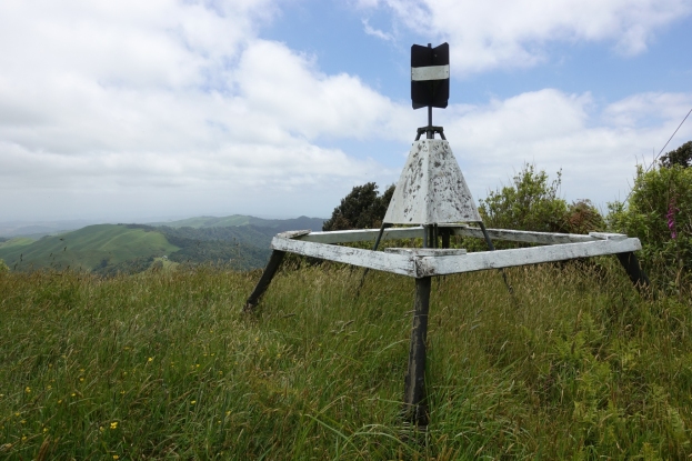
The last part of the ascent is through the grass area, and along the vehicle track visible to the left. There is one large steel mast and two smaller wooden poles for transmission aerials.

The steel mast, with a shed for equipment. The trig station is just off the left edge.

The haze limits the view from the summit. Vegetation limits the views to the east, but in all the other directions there are wide-ranging views.

The trig station at the summit, at 535 metres above sea level.

Views towards the south, looking from the trig station.

The GPS tracklog shows the Hapuakohe Walkway route from Ohinewai Road to the trig at the summit of Maungakawa. The total distance was 3 km, and it took 2 hours 10 minutes for the walk. The walkway crossing of Ohinewai Road is shown incorrectly on this map.

The elevation chart shows the distances and the elevation on the walkway, with Ohinewai Rd on the left and Maungakawa trig on the right. The stream crossing is at the lowest point of the chart.

The aerial photo, taken from Google Maps, shows the same area as the GPS tracklog.

The topographic map excerpt shows the Hapuakohe Walkway by Ohinewai Road in the correct location

Instead of returning to Ohinewai Road by the walkway it is possible to follow the fenceline all the way from the summit to Ohinewai Road. This is considerably shorter and faster than the official track through the bush.

Part of the fenceline, especially near the bottom, is quite steep, and the vegetation will gradually grow across to the fence and make progress difficult. Ohinewai Road crosses in front of the plastic water tank from lower left to upper right.

Looking from Ohinewai Road up the fenceline leading to the summit. A short netting fence with a timber beam along the top prevents stock from entering the bush reserve.

Following the fenceline instead of following the walkway made the return considerably shorter, at 2.3 km including about 750 metres walking along Ohinewai Rd back to the track start location. The time was also much shorter, at 1 hour 10 minutes. The GPS tracklog shows the fenceline and Ohinewai Road route back, with the elevation chart showing the distances and elevation changes.


The track was walked on December 9, 2018.
