Tag Archives: Tauranga

Te Puna Quarry Park – Part 2

Te Puna Quarry Park, at the end of Te Puna Quarry Rd off SH2 west of Te Puna near Tauranga, is one of the most popular walks in the Western Bay of Plenty. The park covers about 32 hectares of disused quarry.

Te Puna Quarry Park – Part 1 covered some of the history of Te Puna Quarry Park, and the western part of the park with the sculptures, plants, and facilities. Part 2 covers the East Block Native Bush Walks. The official Te Puna Quarry Park web site apparently makes no mention of the native bush walks, and only shows a part of them on the map on the Visit the Park page.

Continue reading

Te Puna Quarry Park – Part 1

Te Puna Quarry Park, at the end of Te Puna Quarry Rd off SH2 west of Te Puna near Tauranga, is one of the most popular walks in the Western Bay of Plenty. The park covers about 32 hectares of disused quarry. Closed in 1970, the quarry has been transformed by volunteers, starting in 1993 with the formation of the Te Puna Quarry Park Society, and granted reserve status in 1996.

The park consists of two main parts – the western part with numerous paths and walking tracks, waterways, native and exotic gardens, sculptures, playground, and picnic areas, and the eastern part with tracks, some of them steep and with small stream crossings, through regenerating native bush.

Continue reading

Otawa Trig from Te Puke Quarry Road

The Otawa Scenic Reserve in the Papamoa Hills is part of the Kaimai Mamaku Forest Park. The scenic reserve is accessible from various location near Tauranga and Te Puke, including Te Puke Quarry Road, Manoeka Rd, and Demeter Rd. The Trig Track runs from Te Puke Quarry Rd, via the Otawa trig, to Manoeka Rd by Otawa Lodge.

This walk covers the track from Te Puke Quarry Rd, past the Otawa trig, to the junction where the track to Manoeka Rd joins the track to Demeter Rd and to Whataroa Falls and Otanewainuku.

Continue reading

Omanawa Falls

NOTE – December 2023: For an update post with information access and new facilities see the post Te Rere o Ōmanawa/Ōmanawa Falls (Update).

NOTE: There is no longer any public access to the falls viewing area, and there has never been public access to the base of the falls. The access track has been closed for safety reasons, and will remain closed until safe access can be provided, including, hopefully, to the base of the falls. Please see the comments at the end of this post, which remains as a historical record, and please do not attempt to access the Omanawa Falls.

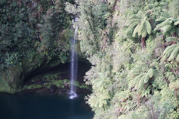
Omanawa Falls and the plunge pool below it can be seen from a viewing area above the falls, about 15 minutes easy walk from Omanawa Rd. The falls are about 20km by road south-west of Tauranga.

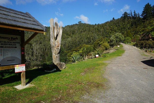
There is a small parking area by the road, but no facilities or information except for a small sign pointing to the access track.

The Omanawa River plunges about 35m in a single fall. The water from the river is partially diverted through the Omanawa Falls Power Station, the first underground power station to be built in the Southern Hemisphere. The original power station was built in about 1915, and rebuilt and restarted in 2008 after being closed for some years.

Unfortunately with the power station running again there is less water in the waterfall, being reduced to almost a trickle despite ample recent rainfall.

Continue reading

Ngamuwahine and Ngamuwahine Loop Tracks

The Ngamuwahine and Ngamuwahine Loop Tracks on the northern slopes of the Kaimai Ranges in the Kaimai Mamaku Forest Park are accessible from the end of Ngamuwahine Road, off SH29, about 25km south of Tauranga. Ngamuwahine Road, about 3km long, is gravel, winding, and only about 1 vehicle width most of the way. So meeting with other traffic usually means one of them reverses to the nearest suitable passing spot.

Tauranga Intermediate School administers an outdoor education facility, the Ngamuwahine Outdoor Education Lodge, at the end of Ngamuwahine Road. There is a large grass parking area and picnic area at the end of the road, by the entrance to the lodge and the start of the track. But there are no toilet facilities on or near the track.

The tracks pass through regenerating native forest, with a number of pine trees in between. All the tracks are under tree cover, so will stay moist for most of the year.

Continue reading

I’Anson Reserve

The I’Anson Reserve or I’Anson Bush Reserve is on a parcel of land gifted to the QEII National Trust in 1987 by K & T I’Anson. Over the years it has been turned from pasture to native bush and a small lake – Lake Taki – has been formed by damming the Waikaraka Stream. Planting has been done by Tauranga Forest & Bird, and the reserve is managed by the Western Bay Of Plenty District Council.

Continue reading

Puketoki Reserve

Puketoki Reserve is only a short distance from Tauranga, accessible from Leyland Rd, off Whakamarama Rd. The reserve consists of 85 acres of bush, donated to the Whakamarama Community by Mr Henry H Sharplin of the Whakamarama Land and Timber Company in 1926. Before that time it was milled, so the only old surviving trees would be those not suitable for timber at that time. Tramways for transporting logs passed through the reserve, and in a few places the location of the tramways can still be seen. Continue reading

Papamoa Hills Cultural Heritage Regional Park

Note: See the post Pāpāmoa Hills Cultural Heritage Regional Park (Update) for information on the new parking area, park entry, and new tracks opened in November 2023.

Note: The park reopened on June 3, 2017 after being closed since October, 2016 for pine tree harvesting.

New photos taken after the re-opening at the end of the post.
————————————–

The Papamoa Hills Cultural Heritage Regional Park near Tauranga was opened in 2004 as the first regional park outside the Auckland and Wellington regions. It contains a number of early Maori pa sites within a small area, with ditches, middens, and terracing on the hillsides.

The main walkway starts by a carpark at the end of Poplar Lane, off SH2 between Tauranga and Te Puke, and ascends through radiata pine forest to open farmland, and the pa at highest point in the park. There are walkways to other pa sites, and to the Summerhill mountain biking tracks.

Continue reading

Mt Maunganui/Mauao

Mt Maunganui/Mauao, or simply “The Mount”, is a 231m high volcanic cone at the end of a narrow peninsula, with Tauranga Harbour on one side and the Pacific Ocean on the other. Mt Maunganui town, on the peninsula, is a suburb of Tauranga.

The mountain is a popular recreational area. The track around the base is well formed and an easy walk with no steep areas. There are two main tracks leading to the summit. One is a 4WD track, and a relatively easy walk, but with slippery small stone chip on the steeper parts. The other is a steeper track with a number of steps. Some of the previously accessible steeper tracks are no longer open, due to slips.

Continue reading

Otanewainuku – Rimu Loop – Whataroa Falls


The tracks to the summit of Otanewainuku and to the Whataroa Falls are accessible from Mountain Rd, off Oropi Rd and No 2 Rd, a few kms south of Tauranga. There is a parking area by the gravel road, with covered picnic tables and toilet facilities by the carpark.

The climb from the carpark to the summit is about 200m, and is signposted as being a 45-minute walk. The track forms a loop, which can be walked either clockwise or anticlockwise. Clockwise gives the gentlest uphill walk, with stepper downhill. The track is well formed and well maintained, with very few steps and steeper areas. There is a lookout tower at the summit, with an almost 36-degree view over the top of the surrounding vegetation. On a day with clear visibility the views are impressive. Continue reading