Author Archives: nzartig

Whakaari / White Island

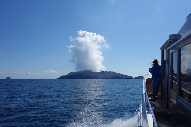
Note – After the tragic events on December 9, 2019 with an eruption occurring while a tour group was on the island, resulting in multiple fatalities and serious injuries, tours to the island have been put on hold indefinitely.

Whakaari / White Island is a privately owned volcanic island in the Bay of Plenty, about 50 km from Whakatane. It is one of New Zealand’s most active volcanoes, and is in a more or less permanent state of activity, with occasional extra activity. The island is about 2 km in diameter, and the highest point, Mt Gisborne, is 321 m high. The acidic crater lake is only a few metres above sea level.

The island has been used for sulphur mining at various times, the last being in the 1930s. Some attempts have been terminated by eruptions, but the last attempt was terminated due to the insufficient accessible sulphur. Some remains of the sulphur mining are still present on the island. Continue reading

Leyland O’Brien Tramway Track

The Leyland O’Brien Tramway (or Tramline) Track follows the route taken by a tramway last used many years ago to extract logs from the forest in the Kaimai Range. The northern end of the track is at the end of Whakamarama Road, and the southern end is at a junction with the North / South Track which runs along the length of the northern end of the Kaimai Mamaku Forest Park. On the way it joins up with the Ngamuwahine Track.

The DoC web site has information about the track. However, the expected time of 2 hours in each direction does not agree with the DoC panels along the track, and the actual walking time was about 2 hours 15 minutes without any breaks. One of the few tracks where the actual walking time was longer than the DoC posted time. Continue reading

Te Puna Quarry Park – Part 2

Te Puna Quarry Park, at the end of Te Puna Quarry Rd off SH2 west of Te Puna near Tauranga, is one of the most popular walks in the Western Bay of Plenty. The park covers about 32 hectares of disused quarry.

Te Puna Quarry Park – Part 1 covered some of the history of Te Puna Quarry Park, and the western part of the park with the sculptures, plants, and facilities. Part 2 covers the East Block Native Bush Walks. The official Te Puna Quarry Park web site apparently makes no mention of the native bush walks, and only shows a part of them on the map on the Visit the Park page.

Continue reading

Te Puna Quarry Park – Part 1

Te Puna Quarry Park, at the end of Te Puna Quarry Rd off SH2 west of Te Puna near Tauranga, is one of the most popular walks in the Western Bay of Plenty. The park covers about 32 hectares of disused quarry. Closed in 1970, the quarry has been transformed by volunteers, starting in 1993 with the formation of the Te Puna Quarry Park Society, and granted reserve status in 1996.

The park consists of two main parts – the western part with numerous paths and walking tracks, waterways, native and exotic gardens, sculptures, playground, and picnic areas, and the eastern part with tracks, some of them steep and with small stream crossings, through regenerating native bush.

Continue reading

New Chums Beach

New Chums Beach, in Wainuiototo Bay, is only accessible by boat, or by foot from Whangapoua Beach. The walk from Whangapoua Beach is relatively easy, but there is a rather difficult but short side track to the 72m high summit of Whangapoua hill at Motuto Point for excellent views of New Chums Beach and Whangapoua Beach.

New Chums Beach has been in the news recently, with protests over plans to subdivide land for holiday homes near the beach. Presumably this would be the farmland which is visible on some photos, but which is not visible from the beach itself.

Continue reading

Opera Point Historic Reserve

Opera Point Historic Reserve is located on a small peninsula on the south-eastern end of Whangapoua Beach on the Coromandel Peninsula. It includes the historic Raukawa Pa site, at 85m above sea level. The only marked walkway is from the parking area on Whangapoua Road to the beach at Opera Point. Another, unmarked, rough track leads from near the carpark to the pa site on top of the hill, and down to the beach. It’s possible to walk along the beach to Te Rehutae Point.

From the pa site there are views across the harbour entrance to Matarangi, and further out to sea.

Continue reading

Cathedral Cove, Coromandel Peninsula

Cathedral Cove with its small sandy beach is only accessible by boat, or by foot from Hahei. The walkway is accessible from either Hahei Beach, or from the end of Grange Road, north-west of Hahei. Two other beaches, a sandy beach in Stingray Bay and a stony beach in Gemstone Bay, are accessible on short side tracks from the same walkway.

The rock arch, or cathedral, is an archway or cave linking Cathedral Cove and Mares Leg Cove. It is a popular destination for both tourists and locals, so the walkway can be busy all year round. The track is well formed and easy, without significant elevation changes, except for a short section with steps at the Mares Leg Cove end of the track. Continue reading

Howarth Memorial Wetland Walkway – Te Aroha

The Howarth Memorial Wetland is a wildlife reserve created in a disused former rubbish dump by the Waihou River in Te Aroha. The walkway runs around the perimeter of the wetlands, and is also used by cyclists.

There are several access points to the walkway. The former railway bridge off Terminus St has been converted to a walking/cycling bridge, leading across the Waihou River directly to the walkway. It’s also accessible from the netball courts on Spur St where there are also parking facilities. There is also an entry off Ritchie St, a residential street.

Continue reading

Raparapahoe Falls

Raparapahoe Falls is a 3-metre high waterfall on the Raparapahoe Stream, plunging into a large pool at the bottom of a valley with very steep sides. The stream and waterfall is accessible by a short but steep and rough track starting at a small parking area on No 4 Road near Te Puke. A narrow bridge on No 4 Road crosses over Raparapahoe Stream not far from No 3 Road, with the road continuing through mainly kiwifruit orchards to the parking area and track start. It continues on to another narrow bridge, crossing over Wairapukao Stream, a tributary to Raparapahoe Stream.

Continue reading

Otawa Trig from Te Puke Quarry Road

The Otawa Scenic Reserve in the Papamoa Hills is part of the Kaimai Mamaku Forest Park. The scenic reserve is accessible from various location near Tauranga and Te Puke, including Te Puke Quarry Road, Manoeka Rd, and Demeter Rd. The Trig Track runs from Te Puke Quarry Rd, via the Otawa trig, to Manoeka Rd by Otawa Lodge.

This walk covers the track from Te Puke Quarry Rd, past the Otawa trig, to the junction where the track to Manoeka Rd joins the track to Demeter Rd and to Whataroa Falls and Otanewainuku.

Continue reading